The Annapurna Base Camp Trekking map provides a detailed layout of the trekking route through the Annapurna region, highlighting key stops such as Ghorepani, Chhomrong, and Machhapuchhre Base Camp. It includes elevation profiles, notable viewpoints, and major landmarks, serving as an essential guide for trekkers.
The Annapurna Base Camp (ABC) Trekking is one of the most stunning and well-liked treks in Nepal. It leads you to the foot of the majestic Annapurna Mountains after passing through serene villages, forests, and rivers. Using a map is quite helpful to ensure that you stay safe and enjoy this excursion to the fullest. A map indicates your daily destination, the distance you must walk, and the sights you will encounter.
Everything you need to know about the Annapurna Base Camp trekking map will be included in this guide. You'll discover how to read the map, the starting and finishing points of the walk, the villages you'll pass, and the elevation gain.
The best ABC trekking map formats to use, such as paper maps and smartphone apps, will also be covered. A decent map boosts your confidence and aids in better planning, whether you are walking alone or with a guide. This guide has been prepared to make the ABC trek easier to understand for all trekkers, especially beginners. We will explore how a map can enhance the ease, security, and enjoyment of your Annapurna experience.
Annapurna Base Camp Trek Map Overview
Trekking to Annapurna Base Camp (ABC) is one of the wonderful journeys in Nepal. It takes you far into the Annapurna mountain range, where you can get up close and personal with snow-capped peaks like Hiunchuli, Machapuchare, and Annapurna I. It typically takes 7 to 12 days to complete the trek, depending on where you start and how fast you walk.
It is important to have a thorough understanding of the route before beginning the trek. A decent Annapurna Base Camp trekking map can help with that. With the help of a Annapurna trekking map, you can determine your destination, the daily walking distance, and the locations of the villages, rivers, and mountains. It indicates where teahouses are located, where you can relax, and the trail's ups and downs.
The ABC trek passes through high alpine regions, forests, and communities. You can better organize your days and prepare for the future with the use of a map. It keeps you safe, particularly if you're traveling by yourself or without a guide.
The ABC trekking Map is available on a variety of map types. You can hold certain printed maps in your hand. Others are cell phone-compatible digital maps. To be safe, many trekkers carry both kinds because they are both handy. A decent map makes your trek easier. It gives you greater confidence to enjoy the stunning drive to Annapurna Base Camp, track your progress, and have a better understanding of the area.
Trekking Route Map for Annapurna Base Camp

The major trekking trail of Annapurna Century trek is shown on the route map. It helps you to understand the trail's beginning, the villages you will encounter, and the trek's ending point. The trekkers start their journey either from Nayapul, Phedi, or Ghandruk, depending on their itinerary.
From Nayapul, you pass through lovely villages like Tikhedhunga, Ghorepani, and Tadapani on your way. For views of the sunrise, trekkers opt to travel to follow Ghorepani to Poon Hill map. The trail then continues to Chhomrong, a popular destination where you can pause to view the scenery. The trail then heads up into the forest in the direction of Machapuchare Base Camp (MBC), Bamboo, Dovan, and Deurali. At last, you arrive at Annapurna Base Camp, the trek's highest point at about 4,130 meters.
This trek is shown well on the Annapurna century trekking route map, which includes the names of the villages, the trail, and the distances to each stop. You may also witness the mountain peaks, rivers, and jungles along the route. You can tell when a trail is going uphill or downhill since most maps also indicate altitude changes. There is no straight path on the ABC trip. There are other ways to go back, and some trekkers choose to go one way while others choose to go another way. All of the alternative routes, including detours like the Jhinu Danda hot springs or a longer circuit that passes via Mardi Himal or Poon Hill, will be displayed on a good route map.
You can better plan your walk, remain on course, and expect each day's events by using the route map. It's among the greatest resources for trekkers who go it alone or with a guide.
Annapurna Trekking Map Guide
Your ABC trekking might be more enjoyable and easier if you use a ABC trekking map. However, knowing how to interpret your map correctly is helpful if you want to get the most out of it. We'll examine how to use a trekking map for the Annapurna Base Camp route in this part.
You should first become familiar with the map's icons. Signs indicating communities, tea houses, rivers, bridges, forests, and peaks are among them. Every map has a little box known as a "legend" or "key" that explains the meaning of each symbol. Health stations, camping spots, and viewpoints are also marked on certain maps.
The map also displays contour lines. These lines show variations in elevation or height. The trail is steep when the lines are close together. The trail is simpler and more gradual when they are dispersed. You can better prepare for challenging climbing sections or easy walking roads by reading these lines.
Additionally, you should be mindful of distances. The distance between stops is indicated on good trekking maps, either in hours or kilometers. You can use this to estimate how much time you'll need and to organize your day. These days, a lot of trekkers utilize digital maps on their phones. Popular apps include Maps.me, Gaia GPS, and AllTrails. Before your trek, you can download the maps offline so you can use them without an internet connection. These applications even use GPS to display your current location, which is quite useful.
To put it briefly, being able to read and use a Annapurna Base Camp trekking route map increases your confidence while trekking. It makes time management easier, keeps you from getting lost, and allows you to appreciate the Annapurna region in solitude.
Best Map for Annapurna Base Camp Trek
Having the best map is crucial while planning your trekking to Annapurna Base Camp. While there are numerous maps available, some are more suitable for trekkers than others. A decent map should display all of the trail's key features and be clear and current.
If you want something you can hold and make notes on with a pen, printed maps are a great option.
- Himalayan Map House produces some of the best printed maps. It displays the entire ABC trekking route, along with altitudes, path lengths, and village names.
- The Nepal Map Publisher has another excellent printed map. Because of its strength and waterproofness, it won't tear easily when you're trekking.
- You can use a digital map on your phone if you choose. Because these apps use GPS to display your location, they are really helpful. Even if you're walking alone, this aids in keeping you on course.
Before your trek, you can get printed maps in Pokhara or Kathmandu. Stores in Thamel offer a wide variety. If you make a reservation with our trekking company, Nepal Trekking Routes, we also provide free route maps. If you want to study maps before your trip, you may also obtain them online.
Look for a map with a scale of at least 1:50,000 when making your selection. This indicates that the map displays a great deal of detail without being overly large. Trails, rivers, forests, mountain summits, and nearby side roads should all be shown on a good map. Ultimately, your trekking style will determine which map is ideal for you. A good map, whether digital or paper, will increase the safety and enjoyment of your trek.
Annapurna Base Camp Trekking Route Details

The trekking route to Annapurna Base Camp is full of serene villages, stunning landscapes, and diverse terrain. You can make better plans and enjoy the trip if you have a thorough understanding of the itinerary.
- Most trekkers start from Nayapul which is a short drive from Pokhara.
- You then pass through settlements like Ulleri and Tikhedhunga.
- Beginning with stone stairs, the trail ascends past terraced farmland and forests.
- Many trekkers head to Poon Hill for views of the sunrise after arriving in Ghorepani.
- The trail leads from Ghorepani to Tadapani and Chhomrong.
- Chhomrong is a significant village with lovely vistas and decent tea houses.
- After that, the trail goes up to Bamboo, Dovan, and Deurali before descending to the river. The air gets colder and the trees get smaller as you ascend.
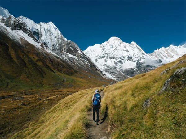
- Then, you reach Machapuchare Base Camp (MBC), which is named after the revered Machapuchare Mountain. It is a fantastic area to pause and rest before making the last push to the 4,130-meter Annapurna Base Camp (ABC).
- The views from ABC are breathtaking, with massive snow-capped peaks on either side.
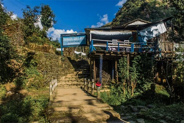
There are lodges and food breaks along the well-marked, secure track. Every village has a teahouse, so you don't need to bring food or a tent. Depending on their pace and itinerary, most individuals complete the journey in 7-12 days.
You will walk through bamboo forests, cross rivers on suspension bridges, and climb several stone stairs throughout the route. It is crucial to take your time and stay hydrated because the trail goes up and down.
Being aware of these route specifics will help you in your physical and mental preparation for the journey. Additionally, it enables you to schedule your stops, avoid hurrying, and savor every moment of the Annapurna trek.
Map of Annapurna Base Camp Trail
The Annapurna Base Camp (ABC) trail is one of the well-traveled trekking routes in Nepal. You can see where you're going, how far you'll be walking, and what to expect along the route by looking at a map of this trail. Before arriving at ABC, the trek often begins in Nayapul or Jhinu Danda and passes through beautiful villages like Ghandruk, Chhomrong, Bamboo, Dovan, Deurali, and Machhapuchhre Base Camp (MBC).
Important sites like tea shops, rivers, forests, and mountain vistas are depicted on the map. Additionally, you can locate the names of mountains such as Machhapuchhre (Fishtail), Hiunchuli, and Annapurna South. You may schedule rest days and acclimatization by using a map to check the altitude of each location.
The Modi Khola river valley is followed by the trail. You can see on the map where the woodland turns alpine, where the trail becomes steep, and where it is easy. This facilitates the planning of your daily walk. Additionally, a lot of maps have symbols for snack breaks, restrooms, and medical posts.
Having a route map is particularly beneficial for beginners. It gives you peace of mind and boosts your confidence. You may monitor your current position, your progress, and the remaining amount. The map helps you enjoy the walk safely, whether you travel with a guide or by yourself.
Variations of the Annapurna Base Camp Trek Map
Annapurna Trekking Distance Map
The Annapurna Base Camp (ABC) trek daily walking distance is displayed on the Annapurna trekking distance map. Planning your trek and estimating the amount of walking required are made much easier with the help of this map. It aids in your physical and mental preparation before the trip starts.
Depending on the starting and finishing locations, the majority of ABC trek span between 70 and 115 kilometers. For instance, it would take about 70 to 80 kilometers to get from Nayapul to ABC by the usual route, which passes through Ghandruk, Chhomrong, Bamboo, and MBC. The distance grows if you include side visits like Poon Hill or Hot Springs.
Every village and camp is indicated on the distance map by how many kilometers it is from the previous location. This makes it simple to estimate the length of the daily stroll. For example:
- Ghandruk to Nayapul: around 10 kilometers
- Chhomrong to Ghandruk: around 8 kilometers
- Bamboo to Chhomrong: around 6 km
- Deurali to Bamboo: around 9 kilometers
- Deurali to ABC: around 9 km
To let you know where the trail becomes steep, the map also displays the elevation gain. While some parts are long yet easier, others are short but extremely steep. This helps in the planning of your overnight accommodations and break times. You can avoid any surprises by using a distance map. You can choose how many days and how quickly you wish to journey by viewing the entire trail with daily distances. During the walk, it also helps you keep track of your daily progress.
Annapurna Base Camp Trek Itinerary Map

Your daily travel from the starting location to Annapurna Base Camp itinerary is shown on map. It serves as a visual guide that explains where to begin, where to spend the night, and what to expect along the route. This type of map is useful for both individual and guided trekkers.
The following is a typical itinerary for Annapurna Base camp trek:
Day 1: Drive from Kathmandu to Pokhara
Day 2: Pokhara to Tikhe Dhunga
Day 3: Tikhe Dhunga to Ghorepani (2750m)
Day 4: Ghorepani to Poon Hill to Tadapani (2520m)
Day 5: Tadapani to Chhomrong (2210m)
Day 6: Chhomrong to Doban (2540m)
Day 7: Doban to Deurali (3170m)
Day 8: Deurali to Annapurna Base Camp
Day 9: Annapurna Base Camp to Sinuwa
Day 10: Sinuwa to Ghandrung (1940m)
Day 11: Ghandrunk to Birethanti, Nayapul, and then drive to Pokhara (910m)
Day 12: Travel back to Kathmandu
Each station is marked on the ABC trekking itinerary map with the altitude, distance, and the projected walking time. This helps in better day planning and prepares you for what lies ahead. You will be aware that the trek from Deurali to ABC is a gradual ascent that could take 5-6 hours. Trekkers who wish to extend their journey can see how these paths connect by looking at the map, which also displays side choices like Poon Hill or Mardi Himal.
Having a map of your itinerary allows you to:
- Stick to a daily schedule.
- Be ready for fluctuations in altitude.
- Choose a place to sleep and relax.
- Avoid getting lost or pushing yourself excessively.
It's a straightforward yet effective tool that keeps you organized and increases the enjoyment of your trek.
Detailed ABC Trek Map
A thorough map of the Annapurna Base Camp trek provides you with comprehensive details about the route, topography, and landmarks. It displays more than simply village names. It also displays avalanche zones, rivers, bridges, woods, contour lines, and route forks. This type of map is very useful for those who like to explore independently or trek without a guide.
The trek's central region, between Chhomrong and ABC, is highlighted in depth on the map. It indicates significant locations such as:
- Himalaya, Deurali, MBC, Sinuwa, Bamboo, and Dovan
- River crossings and suspension bridges
- Zones of decline and steep ascent
- Locations where snowfall or landslides may occur
Changes in altitude are clearly shown on this map. You can observe how the trail gradually rises in elevation before arriving at the base camp, as well as how steep the climb from Bamboo to Deurali is. It helps you in setting your pace and being ready for walking at greater elevations. Some maps even include emergency shelters, restrooms, teahouses and lodges. If you walk more or less than you should each day, this can be a huge help.
In bad weather, a thorough map is especially helpful. A zoomed-in map aids in determining the correct route in the event of snowfall or cloud cover on the trail. It is beneficial to have a map with you, even if you already have a guided. It helps you know where you are and what to expect next.
Annapurna Sancturay Trek Map
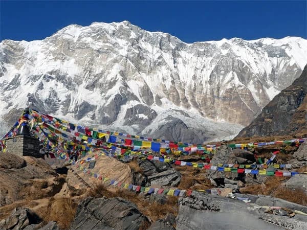
The Annapurna Sanctuary Trek is another name for the Annapurna Base Camp Trek. ABC is located within the Annapurna Sanctuary, a protected area surrounded by Himalayan Peaks. Annapurna Sanctuary trek map gives you a broader view of the whole region, not just the ABC trail. This map shows that the Modi Khola River leads into a valley surrounded by huge mountains like: Annapurna I, Annapurna South, Hiunchuli, and Machhapuchhre (Fishtail).
The Sanctuary is a unique location. To preserve the environment, camping was banned near ABC. It is considered sacred by the locals, and this honors local customs. This map shows the Sanctuary's paths, rivers, forest areas, and glacial areas.
The Sanctuary map gives you a broader view than other maps that only show communities. From low hills and woodlands to high alpine zones and glacier valleys, you can observe the variations in the landscape. Wildlife zones are also indicated on the map. The Sanctuary is home to numerous birds, rare snow leopards, and Himalayan tahr. It's a walk through a live natural museum, not just a trek.
Conclusion: Annapurna Base Camp trekking map
The Annapurna Base Camp trekking map is your guide to understanding the nuances, difficulties, and beauty of one of Nepal's most well-known treks. It is more than just a navigational aid. Whether you're an experienced trekker seeking a new route or organizing your first Himalayan expedition, a decent map enables you to see the terrain, make informed decisions, and appreciate every step. Before you even put on your boots, these maps show the entire Annapurna Sanctuary and indicate the elevation and distance of each day of the trip.
You can plan your route, get ready for steep ascents, and plan rest areas. You can even locate off-the-beaten-path side trails or serene vantage sites by using a trustworthy map. You have the option of printed versions or digital apps, both of which make useful trekking companions. With the aid of useful maps, you will be able to know not only your destination but also the reasons why the Annapurna Base Camp journey is so fulfilling.
Therefore, spend some time studying the ABC trekking map before you start your journey. It is your ticket to a carefully planned, secure, and remarkable Himalayan journey full of wonderful vistas, local customs, and breathtaking scenery.


.webp&w=1200&q=75&dpl=dpl_4U3CaZUV3Y5iKdBNPJmVMATJy3AB)