"How long is the Manaslu circuit trek?" is one of the first things that comes to mind when planning a trek to Manaslu Circuit. It's a important question, but the answer goes beyond just a number. The trek is about more than kilometers, it's about winding paths through beautiful villages, stunning mountain peaks, rushing rivers and the sense of progress you feel one step at a time.
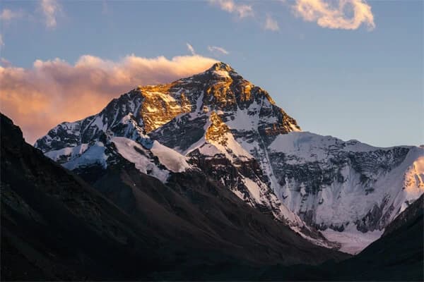
The Manaslu Circuit Trek is one of Nepal’s most remarkable off-the-beaten-path treks. Encircling Mount Manaslu (8,163 m), the eighth-highest peak in the world, the trail offers both solitude and adventure. Knowing the total distance and daily walking requirements is crucial for mental and physical preparation, even though the true reward lies in the journey itself.
Before you set off, it’s helpful to understand the distance, daily walking sections, and duration of this trek. In this guide, we’ll break down the total distance, trekking route, daily kilometers, side trips, and sample itineraries, so you can prepare effectively for the trek.
Overview of the Manaslu Circuit Trek
The Manaslu Circuit Trek is located in the Gorkha District of Nepal and is one of the most remote and less-crowded trekking routes in the country. The trail circles Mount Manaslu (8,163 m), the eighth-highest mountain in the world, offering trekkers a combination of natural beauty, cultural experiences, and adventure.
Along the route, you will pass through lush river valleys, terraced farmland, dense forests, and traditional villages, where locals live in a unique Tibetan-influenced culture. Most trekkers start from Soti Khola or Machha Khola and end at Besisahar or Dharapani, walking through green hills, roaring rivers, and small communities that have preserved centuries-old customs and architecture.
The trek features many highlights, including the Larkya La Pass, the highest point of the journey, which provides breathtaking views of surrounding Himalayan peaks. Samagaun village serves as a hub for acclimatization and exploration, while the Manaslu Base Camp is a popular optional side trip for trekkers seeking close-up glacier and mountain views.
The nearby Tsum Valley, another optional extension, offers a serene cultural and spiritual experience with monasteries and remote villages. Along the trail, you will also enjoy vibrant rhododendron forests, cascading waterfalls, and scenic terraced fields, making the journey both picturesque and diverse.
The Manaslu region is restricted, so trekkers must obtain a Manaslu Restricted Area Permit (RAP) to enter. Additionally, because parts of the trek pass through the Annapurna Conservation Area, trekkers need permits like MCAP and ACAP for those sections. These regulations help preserve the region’s delicate ecosystems while ensuring safe trekking. The Manaslu Circuit is an excellent choice for those seeking a peaceful, less-traveled adventure, offering a rich combination of stunning scenery, high-altitude challenges, and authentic Himalayan culture.
Total Distance of Manaslu Circuit Nepal
The average total distance of the Manaslu Circuit Trek is about 177 kilometers (110 miles) when following the standard route. This distance is usually covered over 12 to 14 days, depending on your walking pace, acclimatization days and weather conditions.
The total distance can change based on the route you choose. If you add popular side trips such as Manaslu Base Camp, Birendra Lake or the Tsum Valley, the trek becomes longer. These side trips usually add around 15 to 25 kilometers to the overall distance.
There are two common route options. The standard route is about 177 km and is suitable for most trekkers with a normal fitness level. The extended route, which includes side trips and extra exploration days, can be around 190 to 200km and usually takes 15 to 18 days to complete. This option is ideal for trekkers who want a slower pace and more cultural and scenic experiences.
Daily Walking Distance and Terrain on the Manaslu Circuit
You may walk 6-8 kilometers on certain days, particularly at higher elevations when the air is thinner. On other days, particularly early in the journey, you may walk 15 to 20 kilometers.
It is not a flat walk. The track features high-altitude climbs, tiny roads carved into cliff sides, suspension bridges, and ups and downs. 177 kilometers may seem manageable, but depending on how your body responds to the elevation and the path, it may feel much longer.
Side trips may also increase your overall distance. For instance, it is well-liked and well worth the extra kilometers to visit Pungyen Gompa or climb up to Manaslu Base Camp from Samagaun. In this way, some trekkers cover an additional 10 to 20 kilometers without even noticing.
This trek falls midway in the middle of other well-known treks in Nepal. It is somewhat shorter than the entire Annapurna Circuit (which, depending on the route, can reach 230 km) and longer than the Everest Base Camp walk (approximately 130 km round trip).
Ultimately, don't be afraid of the distance. A memorable journey may be made out of 177 kilometers with the correct planning, pace, and attitude. You will pass through alpine meadows and waterfalls, enter villages where time seems to have stopped, and stroll through deep river gorges. Yes, it will be a long trek. But you will gain something countless with each step.
Manaslu Circuit Trek 14 Days Itinerary

In northern Nepal, Manaslu Circuit Trek 14-day itinerary leads you through remote mountain communities, deep river valleys, and high Himalayan passes in northen Nepal. From Kathmandu, the journey starts with a scenic drive to the trailhead near Soti Khola. From there, you pass through traditional villages like Jagat, Deng, Namrung, and Samagaun while strolling through green forests and over suspension bridges.
The terrain shifts with elevation, from lowland vegetation to alpine landscapes, glaciers, and views of Mount Manaslu, the eighth-highest peak in the world. After some time spent acclimating, you will pass the trek's highest and most difficult point, Larkya La Pass (5,106 meters). Following the pass, the path winds down through the Bimthang valley before joining the Annapurna region close to Dharapani, ending point of the trek.
Day 1: Soti Khola to Machha Khola - 14 km
The trek begins by following the Budhi gandaki river, passing though lush forests, waterfalls and small gurung villages. The trail includes suspension bridges, rocky paths, and short uphill and downhill sections. you'll walk through terraced fields and hear the sound of the river throughout the day. this day helps your body slowly adjust to walking in the mountains.
Day 2: Machha Khola to Jagat - 15 km
Today’s walk feels more remote as the valley narrows and the trail becomes steeper in places. You pass natural hot springs at Tatopani, cross several suspension bridges, and walk along rugged riverbanks. Jagat marks the official entry into the Manaslu Restricted Area, where your permits are checked for the first time.
Day 3: Jagat to Deng - 19 km
This is a longer and more physically demanding day with multiple ascents and descents. You walk through villages such as Philim and Ekle Bhatti, where Tibetan-style houses and prayer wheels start appearing. The landscape slowly changes, and you begin to feel the influence of Tibetan culture as you move deeper into the Manaslu region.
Day 4: Deng to Namrung - 20 km
The trail climbs steadily today, passing through dense pine and rhododendron forests. You cross wooden bridges and walk through peaceful stone-built villages. The air becomes cooler as you gain altitude, and mountain views begin to open up. Namrung is a beautiful village surrounded by forested hills and snow-capped peaks.
Day 5: Namrung to Samagaun - 17 km
Today is one of the most scenic days of the trek. You walk through alpine terrain with breathtaking views of Mount Manaslu, Manaslu North, and other Himalayan peaks. Traditional villages like Lho and Shyala offer cultural insight and panoramic viewpoints. Samagaun is a large settlement where most trekkers stay an extra day for acclimatization.
Day 6: Acclimatization Day: Optional Side Trip
This rest day is essential for adjusting to the altitude and preventing altitude sickness. You can take short hikes to Manaslu Base Camp, Birendra Lake, or Pungyen Gompa, a remote monastery with stunning mountain views. These hikes add 6-10 km but are well worth the effort. The rest of the day can be spent relaxing and exploring the village.
Day 7: Samagaun to Samdo - 8 km
A short and gentle walk that helps with further acclimatization. The trail gradually climbs through open landscapes with wide valley views. You may spot yaks grazing along the way. Samdo is a small, quiet village near the Tibetan border and one of the last permanent settlements before crossing Larkya La Pass.
Day 8: Samdo to Dharmasala (Larke Phedi) - 6 km
Although the distance is short, the high altitude makes this walk feel more challenging. The trail passes through barren landscapes and glacial valleys. Dharamsala is a simple settlement used mainly as a resting point before crossing the high pass. You’ll rest early and prepare mentally and physically for the next day.
Day 9: Dharmasala to Bimthang via Larkya La Pass - 24 km
The most challenging and rewarding day of the trek. You start early before sunrise and gradually climb to Larkya La Pass (5,160 m), the highest point of the trek. From the pass, you enjoy spectacular views of Himlung Himal, Cheo Himal, and Annapurna II. Afterward, you descend steeply to Bimthang through glaciers and moraine trails. This day is long, tiring, and unforgettable.
Day 10: Bimthang to Tilije - 20 km
The trail descends steadily through alpine meadows, yak pastures, and rhododendron forests. As you lose altitude, the air becomes warmer, and vegetation becomes greener. You pass through villages like Gho, where traditional lifestyles are still preserved. Tilije is a comfortable village with better facilities.
Day 11: Tilije to Dharapani - 10 km
The final trekking day is relatively short and easy. You walk through forested trails and stone paths before reaching Dharapani. This is where the Manaslu Circuit officially connects with the Annapurna region. Most trekkers end their trek here and continue by jeep or bus.
Manaslu Trek Day-by-Day Distance Breakdown
The Manaslu Circuit Trek typically takes 12 to 14 days of walking, depending on your pace, fitness level, and how often you take breaks or explore side trails. Each day’s distance and walking time can vary based on altitude, terrain, and weather. While some days may involve long walks through valleys, others are shorter but include steep climbs at high elevations. Proper planning and acclimatization are essential for enjoying the trek safely.
Below is a detailed daily breakdown of distances and approximate walking times, along with additional notes about the terrain, highlights, and trekking experience for each day.
| Day |
Itinerary |
Distance and Time |
| 1 |
Soti Khola to Machha Khola |
14 km, 6 Hrs |
| 2 |
Machha Khola to Jagat |
15 km, 6 hrs |
| 3 |
Jagat to Deng |
19 km, 6 Hrs |
| 4 |
Deng to Namrung |
20 km 7 hrs |
| 5 |
Namrung to Samagaun |
17 Km 7 hrs |
| 6 |
Acclimatization Day: Optional Side Trip |
|
| 7 |
Samagaun to Samdo |
8km, 4 hrs |
| 8 |
Samdo to Dharmasala (Larke Phedi) |
6 km, 5 hrs |
| 9 |
Dharmasala to Bhimtang via Larkey La pass |
24 km, 8 hrs |
| 10 |
Bimthang to Tilije |
20 km, 6hrs |
| 11 |
Tilije to Dharapani |
10km, 4 hrs |
What Can Affect the Manaslu Trekking Distance?

Although the Manaslu Circuit has a general route that most people use, not everyone walks the same distance. Your voyage may be longer or shorter depending on a few factors.
Side Trips During the Manaslu Circuit Trekking
Many trekkers add short side hikes, especially on acclimatization days, which naturally increase the total distance. One of the most popular is the Manaslu Base Camp hike from Samagaun, which adds roughly 8-10 km round trip but rewards you with dramatic glacier views and close-up scenery of Mount Manaslu.
Another worthwhile excursion is Pungyen Gompa, a peaceful monastery set beneath towering peaks, adding about 6-7 km. A gentle walk to Birendra Lake, just outside Samagaun, is shorter but still adds extra steps. While these hikes increase your total distance, they greatly improve acclimatization and overall experience.
Starting and Ending Point of the trek
Your trek's distance also depends on where you begin and finish. Some itineraries start earlier at Arughat or Lapubesi, adding several kilometers before reaching Soti Khola. Likewise, while many trekkers end at Dharapani, others continue to Besisahar, increasing the total walking distance slightly. These choices often depends on road conditions, availabale transport and time constraints.
Conditions of the Trails
The condition of the Manaslu Circuit trekking trails plays a significant role in how your trek progresses and how challenging each day feels. While the trail is generally well-marked, it passes through remote and rugged terrain, which can include rocky paths, narrow cliffside trails, and muddy forest tracks. Seasonal factors like monsoon rains can make trails slippery and rivers swollen, while winter snow near Larkya La Pass may require caution, additional gear, or temporary detours.
Landslides and erosion are possible in some sections, especially after heavy rainfall, and trekkers may need to follow alternate routes or bridges. Although these obstacles are usually minor, over the course of the trek they can add extra kilometers and slow your pace, making the journey feel longer than the official distance. Proper preparation, flexibility, and awareness of trail conditions are essential for a safe and enjoyable trek.
Altitude and Terrain Challenges
The Manaslu Circuit is far from a flat trek, and the rugged terrain can greatly affect your daily distance. Steep ascents and descents, particularly near the Larkya La Pass, demand extra effort and slow your pace. The trails are often rocky, narrow, and carved into cliff sides, requiring careful footing.
Combined with the high-altitude conditions, where thinner air makes breathing more difficult and fatigue sets in faster, even shorter walking sections can feel much longer than they are. These challenges mean that daily distances may vary depending on your acclimatization, fitness, and comfort with the terrain.
Your Pace and Trekking Style
Every trekker moves differently. Some prefer longer days with fewer stops, while others split tough sections into shorter, more relaxed walks. Stronger and more experienced trekkers may complete the circuit faster, while those prioritizing acclimatization and comfort may take additional days. As a result, the trek can take anywhere from 10 to 18 days, even on similar routes.
Even though the official Manaslu Circuit Trek distance is around 177 km, your actual journey may be longer especially if you include side trips, take alternative starts or exits, or simply slow down to enjoy the surroundings. And that’s completely okay. The Manaslu Circuit is not about rushing through kilometers; it’s about how you experience each one.
Weather and Seasonal Factor
Weather plays a significant role in how far and fast you can trek each day. During the monsoon season, heavy rains can make trails muddy and slippery, showing your progress. In winter, snow near high passes like Larkya La Pass can force detours or extended breaks for safety. Strong winds or sudden stroms at higher elevations may also delay your trek. Understanding seasonal conditions helps you plan realistic daily distances and avoid unnecessary strain or risk.
Group Size and Support
The size of your trekking group and the support you have can influence your pace and distance. Guided groups usually maintain a steady pace suitable for everyone, while solo trekkers or small groups may walk faster or slower depending on experience and fitness. Hiring porters can make long days easier since you carry less weight, allowing you to cover more distance comfortably. Traveling with experienced guides also ensures safe navigation through challenging terrain and altitude adjustments.
Comparing Manaslu Trek Distance to Annapurna Circuit trek
While the Manaslu Circuit is not the longest trek in Nepal, it is one of the most rewarding and scenic routes. Manaslu is known as a “middle-ground” trek in terms of distance but distance alone doesn’t define the challenge or experience.
The Annapurna Circuit trek can vary widely in length depending on where you start and finish, typically ranging from 160 to 230 kilometers (100-143 miles), and usually takes 14-20 days to complete. Multiple entry and exit points, including Besisahar, Chame, or Jomsom, give flexibility but also influence the total distance.
Road developments in certain areas have shortened parts of the original trail, whereas the Manaslu Circuit remains largely remote and untouched, maintaining its challenging and authentic trekking experience.
Overall, while Manaslu may cover fewer kilometers than the full Annapurna Circuit, it offers high-altitude challenges, less crowded trails, and the unique reward of exploring an isolated Himalayan region.
Despite its length, Annapurna has greater infrastructure and more developed paths. In some areas, there are roads, so you may choose to take a bus or jeep to avoid certain parts. This implies that if you desire, you could walk a shorter distance than the entire 230 km.
In contrast, Manaslu is more distant. The majority of the trail is unpaved, so you must walk every step. Despite being shorter than Annapurna, the rugged terrain, minimal services, and restricted opportunities to bypass some sections of the route make it feel more difficult.
Detours and Modifications
Both the Manaslu and Annapurna treks offer optional side trips that can add kilometers to your journey. In Manaslu, popular excursions include visiting Pungyen Gompa, a serene monastery with sweeping mountain views, or trekking to Manaslu Base Camp, which rewards you with dramatic glacier scenery. In the Annapurna region, side trips like Tilicho Lake or detours through remote villages allow for additional exploration. These detours naturally increase your total walking distance, but they are often the most memorable parts of the trek.
Manaslu is ideal if you want a shorter, wilder, and more peaceful trek, where every step feels purposeful and the trail is less crowded. Annapurna, on the other hand, provides more freedom, longer routes, and easier access to roads, teahouses, and amenities. Both treks create unforgettable experiences, reminding trekkers that the journey itself every village, forest, and mountain pass is just as significant as the total distance covered.
Manaslu Circuit Trekking Altitude
The altitude along the Manaslu Circuit Trek is one of the most critical factors that influence your trekking experience. The trail passes through villages and landscapes that vary dramatically in height, starting from around 600-700 meters near Soti Khola and gradually climbing into alpine regions over 3,000 meters. Some of the higher villages, like Samagaun, sit at approximately 3,500 meters, while the majority of the trek remains above 2,000 meters.
At these elevations, the oxygen level in the air decreases, making simple activities like walking uphill, carrying a daypack, or even breathing deeply more strenuous. Your body needs time to acclimatize to prevent altitude-related issues such as headaches, fatigue, nausea, or dizziness. Proper acclimatization days and a slow, steady pace are essential to safely enjoy the trek.
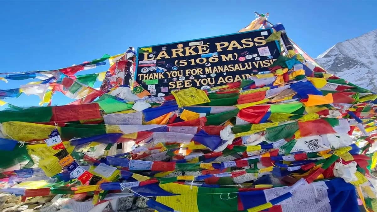
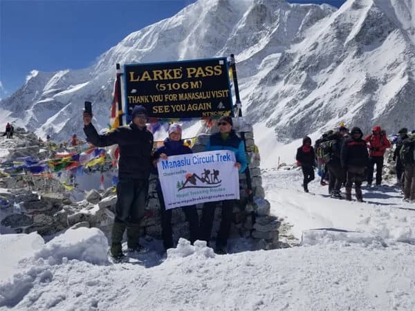
The highest point of the Manaslu Circuit is the Larkya La Pass, at 5,106 meters (16,752 feet). Reaching this pass is the pinnacle of the trek, both literally and figuratively. On this day, trekkers may cover up to 24 kilometers, which, combined with the extreme altitude, can make the day feel significantly longer than it actually is. Temperatures can drop below freezing, winds can be strong, and the thin air requires careful pacing.
Many trekkers consider the Larkya La Pass crossing the most challenging yet rewarding day of the journey. The physical effort is high, but the panoramic views of Manaslu, Ngadi Chuli, Himalchuli, and other surrounding peaks are unforgettable. Successfully crossing this pass provides a strong sense of accomplishment and marks the transition from the high alpine region into the Bimthang valley, where the terrain begins to descend and become gentler.
Backpack Weight for Manaslu Trekking
Carrying a backpack on the Manaslu Circuit trek adds a significant layer of challenge, even if the trek distance is only around 177 kilometers. The combination of altitude, rugged terrainand daily elevation changes makes each step more strenuous than walking the same distance on flat ground.
Even a light backpack with essentials like water, snacks, warm layers and rain gear can feel heavy as you climb steep trails or cross suspension bridges. For longer days, such as Larkya La Pass crossing, the strain is intensified. Hiring a porter to carry heavier gear is highly recommended for those who want to conserve energy, move more comfortably and focus on acclimatization rather than load management.
The true difficulty of the Manaslu Circuit isn't the number of kilometers, it's how your body responds to the thin air, uneven terrain and elevation gain while carrying weight. Trekking at the right pace, taking regular breaks, staying hydrated and following your guide instructions are all essential strategies to maintain stamina and safety.
Remember, the journey is not about rushing through kilometers. Each step allows you to test your physical strength, connect with nature, and soak in the breathtaking Himalayan vistas. A well-planned approach to your backpack and energy management can turn a challenging trek into a deeply rewarding experience.
Tips for Managing the Distance During Manaslu Circuit Trek 14 days
Trekking more than 170 kilometers in the Himalayas is undoubtedly difficult. There are ways to make the experience more pleasurable and easier. Take your time. Your body needs time to acclimate to the high altitudes you will be reaching on this trek. Travel at a leisurely pace, take breaks (particularly in locations such as Samagaun), and stay hydrated.
Don't bring too much. If you are carrying a hefty backpack, the journey may seem significantly longer. Just bring the necessities: basic hygiene, snacks, a rain jacket, and warm layers. You can also hire a porter to carry your stuff if you desire more comfort. Make use of trekking poles. They lessen knee strain, particularly after Larkya La Pass and other lengthy descents.
Pay attention to your health. Rest if you're exhausted. Inform your guide and take it seriously if you have any altitude symptoms, such as a headache or lightheadedness. Enjoy the trip. Enjoy the rhythm of strolling through remote mountain villages, stop to admire the scenery, and say hello to the residents.
Conclusion: Manaslu Circuit Trek Distance
People expect hearing a figure like "177 kilometers" when they inquire about the Manaslu Circuit's distance. However, that figure doesn't tell the whole tale. There are waterfalls, serene woods, historic monasteries, happy kids, and snow-capped peaks around every corner.
Yes, the physical distance is true, but what truly sticks with you are the moments of connection with people along the way, the beauty of nature, and the sense of accomplishment. It is a long trek. But ultimately, what matters is how the experience affects you, not just how far you travel.