What is the Gokyo Cho La Pass Trek map,looks like and why is it important to Everest trekkers? When people think of Nepal trekking, they often see snowy peaks, turquoise lakes, and high mountain passes, but it can be difficult to visualize how these areas fit together. That is where the map is so useful. The Gokyo Cho La Pass Trek is one of the most thrilling routes in the Khumbu Valley. It mixes the beauty of the Gokyo Lakes with the thrill of traversing Cho La Pass and arriving at Everest Base Camp. A map helps you understand how the trail connects all of these landmarks.
The trek begins in Lukla and takes you through famed Sherpa communities, high slopes, and breathtaking scenery. The map depicts the daily evolution of the route, altitude variations, and where side visits such as Gokyo Ri or Kala Patthar fit into the itinerary. It also displays the distances between teahouse stops and rest days, which are critical for good acclimatization.This blog will walk you through the Gokyo Cho La Pass Trek map, discussing routes, highlights, and helpful hints to make your experience more pleasurable.
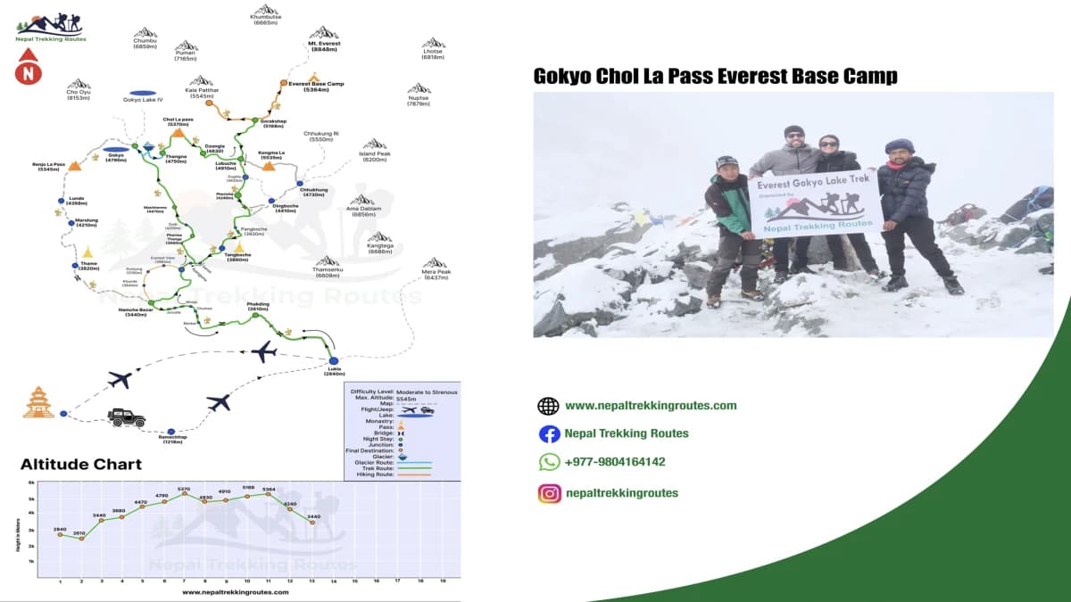
Gokyo Chola Pass Trek Route Map Overview
The Gokyo Cho La Pass Trek is one of the most exciting adventures in the Everest region. When you look at the map, you can see how this route combines the beauty of the Gokyo Lakes, the struggle of Cho La Pass, and the ultimate goal of Everest Base Camp. The trek typically begins with a brief mountain flight from Kathmandu to Lukla, a small airstrip surrounded by hills. From here, trekkers take the classic Everest trekking trail to Phakding, then to Namche Bazaar, the famous Sherpa village.
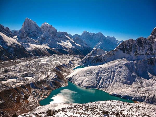
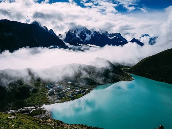
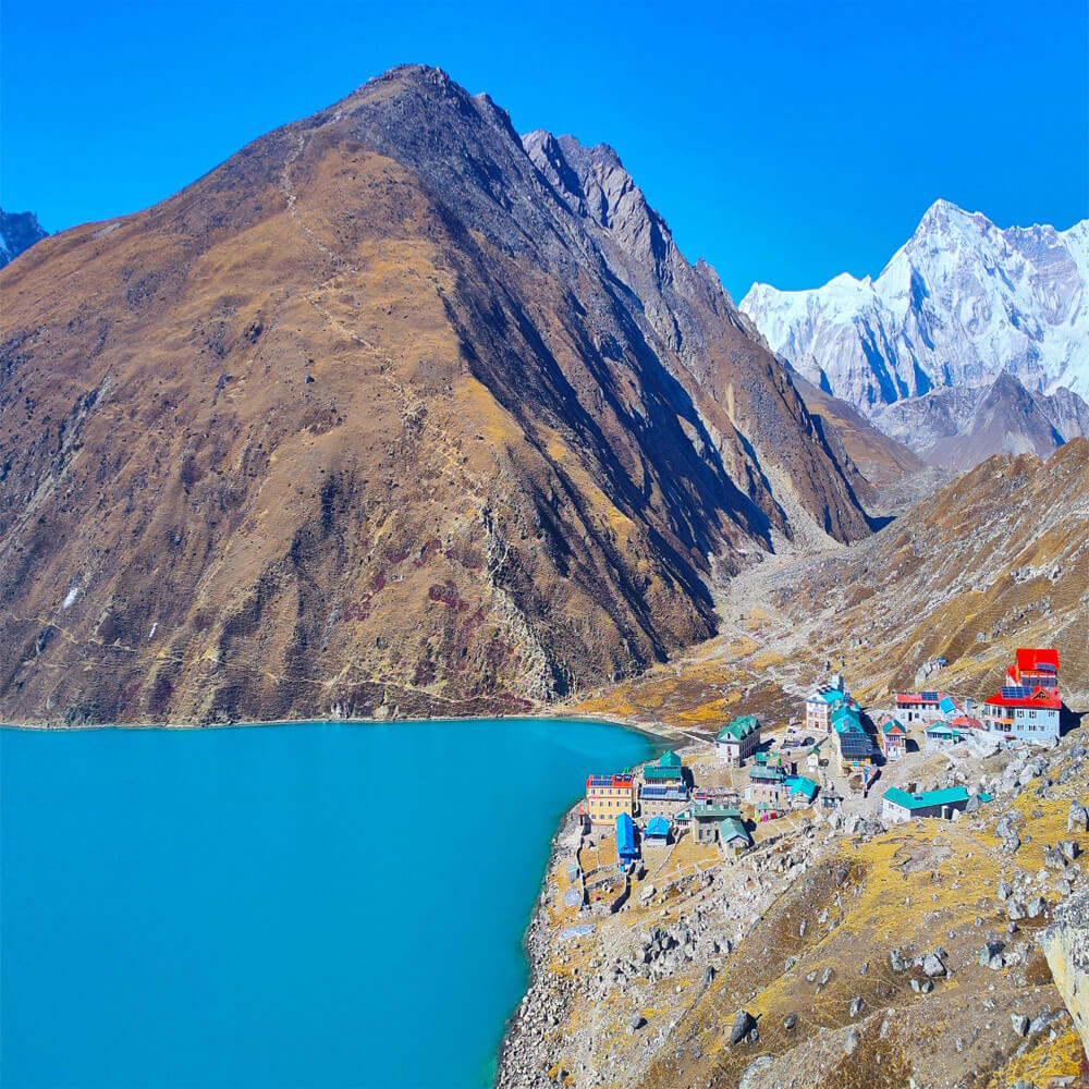
Namche is an important stop on the map since it connects the Everest Base Camp trekking route and the Everest Gokyo Cho La Pass route. Instead of going straight to Tengboche and Gorak Shep, trekkers divert to Dole, Machhermo, and eventually Gokyo. The turquoise Gokyo Lakes and the Gokyo Ri viewpoint are the trail's western highlights, as indicated on the map.
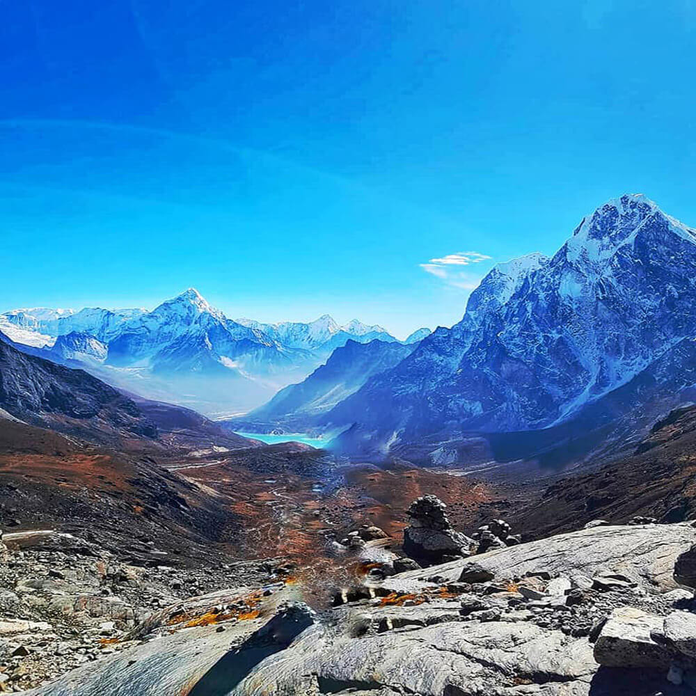
From Gokyo, the trekking trail ascends Cho La Pass, which is marked as one of the most difficult parts on the map. After crossing the pass, the path leads to Lobuche, where it joins the conventional Everest Base Camp trekking route. Finally, the trek heads to Gorak Shep, Everest Base Camp, and Kala Patthar before returning to Lukla. The path on the map looks as a large circle, encompassing both Gokyo Lakes and Everest Base Camp in a single trip.
Key Highlights of Gokyo Chola Pass Trek Map
Several highlights stick out when studying the Gokyo Cho La PassTrek map. The chain of Gokyo Lakes, highlighted as blue jewels at an altitude of over 4,700 meters, is one of the key attractions. These high-altitude lakes are important to both Hindus and Buddhists, and they are frequently the focal point of the western half of the journey. Gokyo Ri is a clearly signposted viewpoint near the lakes. The map depicts how climbing this mountain provides trekkers with an unparalleled perspective of Everest, Lhotse, Makalu, and Cho Oyu in one panorama.
Cho La Pass (5,420 m) is another notable landmark. This is one of the most difficult yet rewarding sections of the Everest Gokyo Cho La Pass route. The map notes the steep ascent and glacier crossing, which makes this section unforgettable. Beyond the pass, Lobuche becomes the key connecting point to the Everest Base Camp trail.
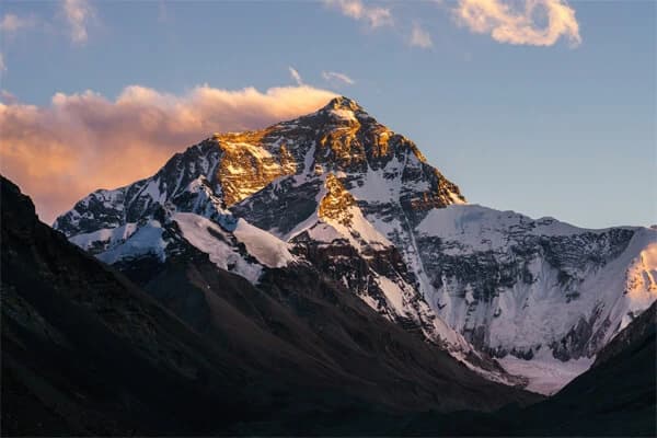
Of course, Everest Base Camp itself is one of the biggest highlights shown on the map. Located at 5,364 meters, it is the closest trekkers can get to the base of the world’s highest peak without climbing. Alongside it, Kala Patthar (5,545 m) is marked as another highlight for its sunrise view over Everest.
The map also shows cultural highlights like Tengboche Monastery, a spiritual center of the Khumbu region, and smaller Sherpa villages that offer insight into local life. Together, these highlights make the trek a balanced mix of nature, adventure, and culture.
Altitude Landmarks of Gokyo Cho La Pass Trekking Map
Altitude is an important aspect of the Gokyo Cho La Pass Trekking, and the map helps trekkers understand how the elevation changes day to day. The journey begins at Lukla, which sits at 2,860 meters. The chart depicts the slow ascent to Namche Bazaar at 3,440 meters, where most trekkers spend an acclimatization rest day.
The chart shows the gradual ascent from Namche to Dole and Machhermo, followed by Gokyo (4,750 meters). This is when altitude really puts trekkers to the test, and the map advises them to take it slowly. Gokyo Ri, at 5,357 meters, is a popular acclimatization trek before crossing Cho La Pass.
The Cho La Pass (5,420 meters) is one of the trek's highest elevations and plainly marked as a difficult landmark. Once trekkers cross this pass, the altitude stays high, with Lobuche at 4,910 meters and Everest Base Camp at 5,364 meters. The highest marked viewpoint is Kala Patthar (5,545 meters), which is famous for its panoramic sunrise vista of Everest.
These altitude landmarks along the Everest Gokyo Cho La Pass route are critical not only for navigation, but also for health and safety. The map assists trekkers in planning acclimatization days, identifying high-risk areas for altitude sickness, and mentally preparing for the next difficult climbs.
Gokyo Cho La Pass Trek Map Distance and Duration
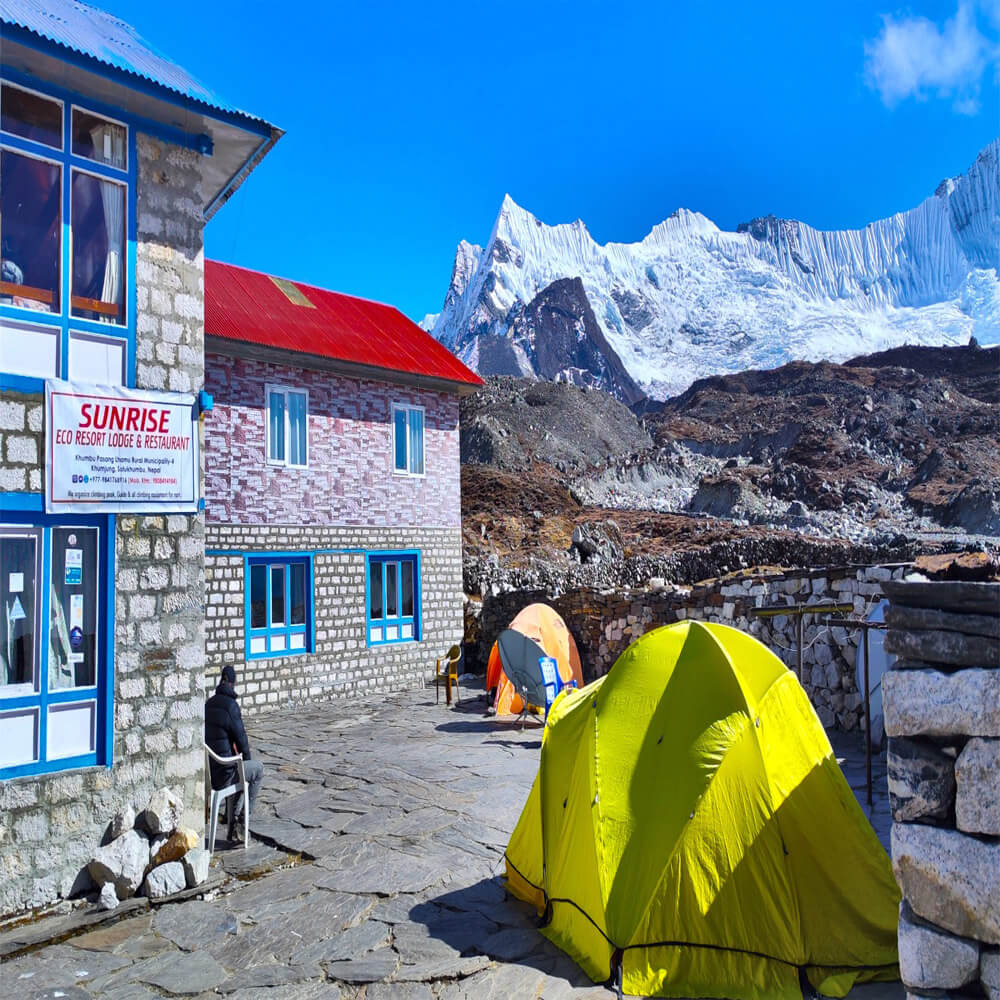
When you first look at a Gokyo Valley trek map, the journey may appear long and complicated, but the distances are actually perfectly spaced to allow for gradual acclimatization. The trek begins at Lukla, which is located at 2,860 meters. The journey to Namche Bazaar normally takes two days and covers approximately 35 kilometers. This part is significant since it introduces trekkers to the altitude, and the map depicts multiple tea house stops along the route.
The Gokyo Valley trek map shows the trail from Namche that leads west to Dole and Machhermo before arriving at Gokyo town. This section takes approximately 4-5 days, depending on how much rest you require. The distances here are shorter often only 5-7 hours of walking per day but the map shows distinct altitude gains, allowing you to arrange rest days to avoid altitude sickness.
The road from Gokyo to Cho La Pass, which is plainly visible on most maps, is one of the most exciting yet difficult sections. The Cho La Pass trekking route connects Gokyo Valley and Lobuche on the Everest side. It takes roughly 6-7 hours of trekking and includes tough climbs across rocky terrain and glaciers. The map shows that this pass is 5,420 meters high, indicating a major elevation rise over previous days.
Finally, the Everest Base Camp via Gokyo map shows the approximately 12-kilometer journey from Lobuche to EBC, which is frequently performed in one long day. Most trekkers spend the night in Gorak Shep before continuing on to Base Camp, as shown on the trail map. The map's distance and duration indications assist trekkers in determining when to rest, when to go harder, and how long the total journey may take.
Side Trips and Alternative Routes During Gokyo Cho La Pass Trek
One of the most thrilling aspects of this excursion is the Gokyo Valley trekking map that clearly shows the side trips. The trek to Gokyo Ri is a must-do, and the map depicts the short but steep trail leading up from Gokyo hamlet. This ascent takes an additional 2-3 hours, but it rewards trekkers with vistas of Everest, Lhotse, Makalu, and Cho Oyu. By consulting the map, trekkers may easily organize this side trip without disrupting their primary itinerary.
Another option on the Cho La Pass trekking route map is to return from Gokyo without crossing the pass. Some trekkers may choose to return to Lukla via Dole and Namche, descending the same valley they came up. This is less strenuous than crossing Cho La, but the chart clearly depicts both routes, allowing trekkers to choose dependent on weather, energy levels, or safety.
The Everest Base Camp via Gokyo ri also indicates variations, such as helicopter return options from Gorak Shep or Gokyo. To save time, many trekkers opt to trek one way and then fly out. Similarly, some maps show the idea of combining the Everest Three Passes Trek, which connects Renjo La and Kongma La as well as Cho La. Having these options visible on the map allows trekkers more flexibility to change their plans.
How to Use Gokyo Cho La Pass Trek Map
Carrying a detailed Gokyo Valley trek map is more than simply a backup; it serves as a guide for acclimatization and daily trekking goals. The map shows you the actual height gains for each day, making it easier to schedule rest stops at Namche, Dole, and Dingboche. It also highlights tea house towns along the trail, allowing you to plan ahead of time where you may find food, lodging, and emergency shelter.
Trekkers who plan to cross the Cho La Pass trekking route may find the map especially useful in spotting steep portions and glacier crossings. Because the weather in this area can change fast, the map helps you understand escape routes and where to turn back if necessary. It also displays the relative distance to Lobuche, allowing you to timing the crossing carefully.
The Everest Base Camp via Gokyo lake is useful for seeing how two well-known treks the Gokyo Valley and EBC trekking routes connect at Cho La Pass. Instead of relying solely on guides, trekkers can track their own progress, compare actual walking times to chart projections, and improve their pace. Digital maps on phones and GPS are useful, but paper maps are more reliable in isolated places where batteries may die.
Finally, the map is more than simply a piece of paper; it is a planning tool, a safety reference, and a means of making your journey more enjoyable. A clear map makes the Gokyo-Cho La-EBC experience more manageable by giving you assurance that every step is in the right path.
How to Read Gokyo Cho La Pass Trek Map
When you first glance at a trekking map, the lines, numbers, and symbols may seem perplexing. But with a little practice, it becomes a highly useful instrument. The Three Passes Trek Map Nepal shows not only the main trail, but also the high passes, side routes, and communities along the way. Learning to read this type of map allows you to determine how much you need to climb or descend in a single day. For example, contour lines that are close together indicate a steep segment, but lines that are further apart indicate a gentler slope.
Altitude points are another useful feature on the map. These indicators are significant because altitude influences how you walk, how quickly you move, and where you should take rest days. Reading the Gokyo Ri trek map allows you to see exactly where the climb to Gokyo Ri begins and how high it goes, which helps you calculate your energy and water requirements.
It is also advisable to consult the map to estimate walking times. While charts do not provide exact hours, the distance between villages and altitude increase can provide a decent estimate. If you anticipate a day with a long climb and few villages in between, you should start early and have extra refreshments.
Maps are more than just directions; they are also about safety. Knowing where emergency exits are, such as roads leading down to lower elevations, can make a significant difference in the event of altitude sickness. That is why every trekker should thoroughly examine the map before and during their journey.
Where to Find Reliable Gokyo Cho La Pass Trek Maps
Finding a reputable trekking map is equally vital as learning how to read one. In Kathmandu, detailed maps are available at bookstores and trekking shops in Thamel. Many of these maps feature not only the Gokyo Cho La Pass route, but also the entire Three Passes Trek Map Nepal, which covers Renjo La, Cho La, and Kongma La. This style of map is very useful if you intend to extend your journey or keep choices open.
Another nice option is to get a Gokyo Ri trek map in Namche Bazaar. Many businesses provide local versions emphasizing the side trek to Gokyo Ri and the surrounding lakes. Online, you can also download digital versions that are suitable for mobile devices. However, it is always advisable to bring a hard copy because the cellphone power may run out in the highlands.
If you book with our agency, Nepal Trekking Routes, we will usually provide a free or low-cost map before the journey begins. These maps are designed for trekkers and usually show tea houses, rest stops, and altitude points. Choosing a reliable map source ensures that you don’t miss important details and that your journey remains safe and enjoyable.
Variations of Gokyo Cho La Pass Trek Map
The Gokyo Cho La Pass Trek is one of the most thrilling adventures in the Everest region. A map of this walk is quite important because it depicts the route, major sights, and elevation points. It explains how the trail goes through many villages, lakes, and mountain passes before reaching Everest Base Camp. With so many side trips and crossing locations, a map serves as a guide for both safety and enjoyment. Some of the major sections follow, each explaining a significant aspect of the Gokyo Cho La Pass Trek map.
Gokyo Cho La Pass Route Map
The Gokyo Cho La Pass trek is one of the most thrilling journeys in the Everest region trekking, and the route map demonstrates how varied and adventurous the trail is. The map normally starts in Lukla, where most trekkers fly in from Kathmandu. The trail then continues via Phakding and Namche Bazaar, the Khumbu region's primary trading area.
Looking at the Gokyo Cho La Pass route map, you can see how the track gradually climbs in altitude, giving trekkers time to acclimate. Before arriving in Gokyo Valley, the road splits between Dole and Machhermo. The main attraction here is Gokyo Lake, which is prominently highlighted on the map, with side paths leading to Gokyo Ri, the famed viewpoint that provides a panoramic view of Everest, Lhotse, and Makalu.
The map shows the route from Gokyo to the Cho La Pass, one of the trek's most difficult but fascinating stages. The pass, located at an elevation of around 5,420 meters, is typically marked with contour lines and elevation signs to warn trekkers of the task ahead. After crossing Cho La, the chart directs the way to Dzongla and Lobuche before connecting with the conventional Nepal Everest Base Camp trekking route. Seeing this connection on the map helps trekkers comprehend how the Gokyo lake trekking route connects with the more popular EBC trekking, resulting in a whole Himalayan adventure.
Everest Region Trekking Map
The vastness of the Khumbu Himalayas becomes obvious when you zoom out to the larger Everest region trekking map. The map depicts all of the major trekking routes, showing how they connect and where they depart. The Everest Base Camp route, the Gokyo Valley route, the Cho La Pass connection, and even trails leading to the Three Passes Trek are frequently linked together, allowing trekkers a variety of alternatives for preparation.
Namche Bazaar, Tengboche Monastery, Dingboche, and Gorakshep are all easily identifiable monuments. The chart also shows the altitude of each stop, which is helpful for determining acclimatization requirements. For example, you can observe the jump from Namche at 3,440 meters to Dingboche at 4,410 meters, and finally to Lobuche at 4,940 meters. This visual style reminds trekkers why rest days are essential.
The Nepal Everest region trekking map also includes side peaks and vistas like as Kala Patthar and Gokyo Ri, as well as glaciers like Nepal's longest, Ngozumpa Glacier. These markers indicate that the trek is about more than just reaching Everest Base Camp; it is also about exploring valleys, lakes, and passes to enrich the adventure. Trekkers can select routes that are appropriate for their fitness, time, and interests by reviewing the entire region map.
Gokyo Valley Trek Map
The Gokyo Valley trek map is a specific segment of the greater Everest trekking map that focuses on the westward valley with the famous Gokyo Lakes. The valley is marked with obvious markings for its six main lakes, with Gokyo village located around the third lake. The map frequently indicates side routes, such as the hard climb to Gokyo Ri, a favorite sunrise and sunset viewing spot.
This image also depicts how the Ngozumpa Glacier spans the valley, making it a key aspect of the expedition. Trekkers can see where the trail crosses stony moraine parts and how the environment transitions from forested lower areas to high alpine landscapes by examining contour lines and glacier pathways.
The Gokyo Valley trek map is especially beneficial for trekkers who choose to stay in the valley rather than crossing Cho La Pass. It displays different return routes back to Namche Bazaar, which is useful for those looking for a quicker itinerary. It also visually relates to the Three Passes Trek by demonstrating how the valley connects to Renjo La Pass and the higher Khumbu routes.
Trekkers who study this map gain a profound appreciation for the valley's natural beauty and find it easier to arrange daily walking hours, tea house stops, and exploring locations.
Cho La Pass Trekking Route
The Cho La Pass is one of the most difficult but rewarding sections of this expedition. On the map, it is located between the Gokyo Valley and the Everest Base Camp Trail. The path begins in Gokyo hamlet and progressively climbs to Dragnag, the starting point for the Cho La Pass crossing. The map indicates a hard ascent up to the 5,420-meter pass. Glaciers, rocky areas, and snow mark the trail throughout the year.
After crossing the pass, the map leads to Dzongla and then to Lobuche, where it connects with the main Everest Base Camp trek route. This area of the map is critical since it emphasizes the elevation difference and difficulty level. Trekkers can track how much they climb and descend in a single day. The Cho La Pass trek is a true connector route, and without a map, it is easy to underestimate the work required to traverse.
Everest Base Camp via Gokyo Map
Another crucial aspect on the map is how this journey gets to Everest Base Camp via Gokyo. Normally, trekkers travel from Namche Bazaar to Tengboche before continuing to Everest Base Camp. However, the Gokyo Cho La Pass map shows that the trail begins with a longer but more scenic loop in the Gokyo Valley.
The map emphasizes major locations such as Dole, Machhermo, and Gokyo village. Trekkers leave Gokyo, traverse the Cho La Pass, and rejoin the main road near Lobuche. From there, the map depicts the last push to Gorak Shep, Everest Base Camp, and Kala Patthar. This path is longer, but the chart clearly shows the advantage: trekkers not only reach EBC, but also enjoy the beauty of the Gokyo Lakes.
The map is also handy for scheduling rest days and acclimatization stops. For example, spending a night in Machhermo and Gokyo is clearly depicted, reminding trekkers of the importance of adjusting to the greater altitude before proceeding to Cho La Pass.
Gokyo Ri Trek Map
On the Gokyo Ri Trek map, one of the most fascinating side trips is the ascent to Gokyo Ri. This is a viewpoint right above Gokyo village, and the trail indicates a short but steep ascent. At around 5,357 meters, Gokyo Ri provides some of the best panoramic views in the Everest region.
The map depicts the road leading right up from the lakeside lodgings in Gokyo. This portion may appear little in comparison to the longer trails, yet it is quite rewarding. Trekkers can see Mount Everest, Lhotse, Makalu, and Cho Oyu from the summit, as well as the blue Gokyo Lakes below them. Having it on the map urges trekkers not to miss this climb, which is frequently regarded as a highlight on par with reaching Everest Base Camp itself.
Everest Three Passes Trek Map
The Gokyo Cho La Pass Trek map is frequently associated with larger Three Passes Trek map Nepal. Both trails explore the Everest region, passing high mountain passes and seeing well-known overlooks. The Three Passes Trek map depicts Kongma La, Renjo La, and Cho La Passes as they connect several valleys. Trekkers can compare routes and decide whether to cover all three or only Gokyo and Cho La. The map emphasizes the circular character of the walk, providing choices for looping back without retracing the same route. The Three Passes map provides trekkers with a comprehensive picture of how Cho La fits into the Everest expedition.
Lukla to Gokyo Cho La Pass Route
The Gokyo Cho La Pass Trek map accurately depicts the trek beginning in Lukla, the primary access point to the Everest region. From here, the route takes you to Phakding and Namche Bazaar, both of which are key acclimatization stops on most maps. The path then continues via Dole and Machhermo before arriving at the Gokyo Lakes. From Gokyo, the chart depicts the hard crossing of Cho La Pass into Lobuche, which connects the Gokyo Valley to the Everest Base Camp route. Every stretch has altitude markers and estimated walking times. Following the chart from Lukla to Cho La helps trekkers remain on track, schedule rest days, and comprehend the obstacles of each step.
Everest Trekking Trails Map
The Everest trekking trails map shows how several notable routes are interconnected. The Gokyo Cho La Pass trail connects directly to the Everest Base Camp trip, one of Nepal's most popular. The map also depicts the paths that go to Tengboche Monastery, Kala Patthar, and the Khumbu Glacier. By comparing trails, trekkers can determine whether to add variants such as the Three Passes Trek or reduce the itinerary with direct returns. The Everest trekking trail map also shows altitude fluctuations, communities, and other exits in case of emergency. It helps first-time tourists understand how Gokyo and Cho La bring variety and challenge to the standard Everest route.
Gokyo Lakes Trek Map
The Gokyo Lakes trek map emphasizes the stunning high-altitude lakes that are key to this expedition. On the map, trekkers can see a chain of six major lakes, with Gokyo settlement located beside the third lake. Gokyo Ri is also a significant viewpoint, providing one of the best views in the Everest region. The map depicts the road from Namche Bazaar to Dole, Machhermo, and finally Gokyo, with gradual elevation gain. For those looking for a shorter excursion, the map also includes the option of visiting only the lakes and returning without traversing Cho La Pass. The Gokyo Lakes trip map, with its clear lines, is ideal for those seeking adventure as well as scenery.
Frequently Asked Question
Why is a map important for the Gokyo Cho La Pass Trek?
A map helps trekkers understand the route, altitude changes, villages, and rest points. It is essential for planning acclimatization, identifying emergency exits, and staying on track in a region where trails can be confusing.
Can I rely solely on a digital map for this trek?
While digital maps are convenient, they can fail due to poor network or battery issues. It’s recommended to carry a printed map as backup, along with GPS devices if possible, for safety and navigation.
What key points are marked on the Gokyo Cho La Pass map?
The map usually marks Lukla, Namche Bazaar, Dole, Machhermo, Gokyo Lakes, Cho La Pass, Lobuche, Everest Base Camp, and Kala Patthar. Altitude points, tea houses, and side trails are also indicated.
Are there variations shown on the map for different trek options?
Yes, the map often highlights alternative routes, such as returning directly from Gokyo, including Gokyo Ri, or connecting to the Three Passes Trek. It helps trekkers plan based on time, fitness, and weather conditions.
Where can I get a reliable Gokyo Cho La Pass Trek map?
You can obtain maps fromtrekking agencies in Kathmandu or Namche Bazaar, guidebooks, and online sources. For the best guidance and accuracy, Nepal Trekking Routes provides detailed maps and route information.
Conclusion: Gokyo Cho La Pass Trek Map
The Gokyo Cho La Pass Trek map is not just a piece of paper. It is a tool for trekkers to better comprehend the route, settlements, high passes, and important highlights of the expedition. With distinct markers of altitude points, lakes, and pathways, it leads you through some of the most beautiful scenery in the Everest region. A map also aids in safe acclimatization planning, indicating where rest days are required and how long each segment may take. Whether you use it for daily navigation or merely to track your progress, it makes your journey more meaningful and safe. Nepal Trekking Routes offers the greatest maps and guided experiences.