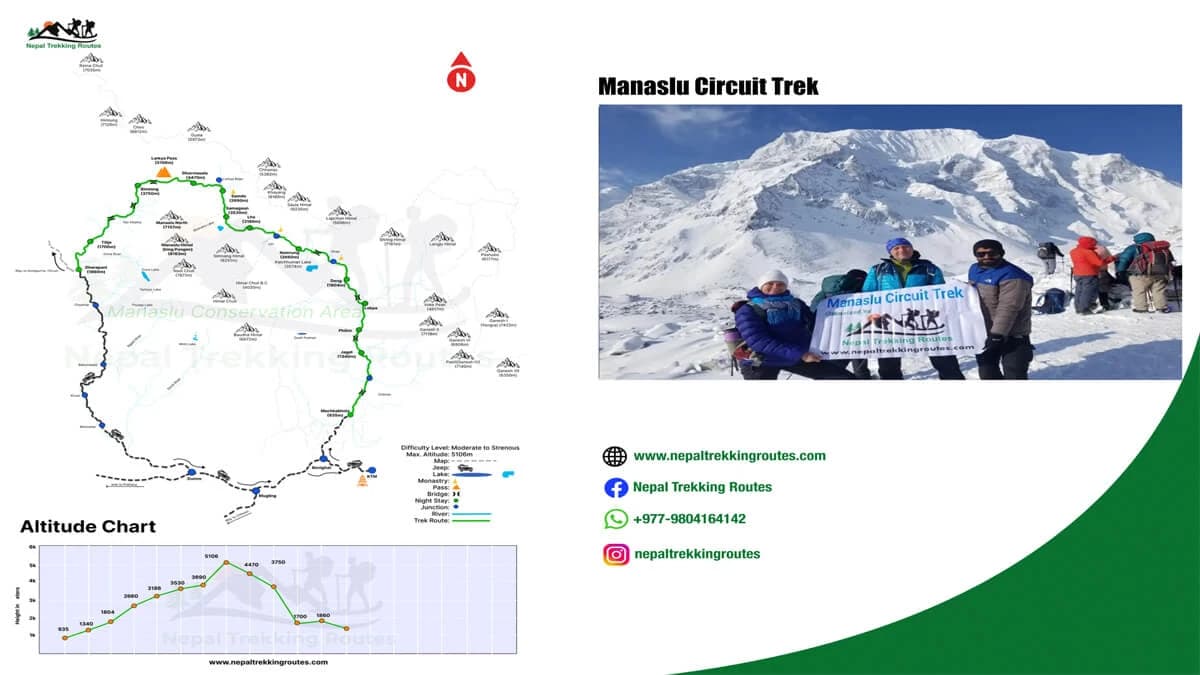
The Manaslu Circuit Trek Map is one of the most essential planning tools for anyone preparing to explore this spectacular Himalayan trekking route in Nepal. As a remote trekking region with rugged terrain and limited infrastructure, the Manaslu trail requires careful navigation and itinerary planning. Unlike the busy Everest trekking route or Annapurna trekking routes, the Manaslu Circuit offers a quieter, off-the-beaten-path trek where a reliable Nepal trekking map helps trekkers understand the route, altitude changes, and daily walking distances.
A detailed Manaslu trekking map shows much more than just the trail. It highlights tea house stops, mountain villages, river crossings, acclimatization points, and key landmarks along the journey. Trekkers can clearly see elevation gain, identify rest days, and prepare for high-altitude sections like the Larke La Pass (5,106 m). It also marks important side trips, including the Manaslu Base Camp side trek or the Tsum Valley extension which makes the route planning easier and safer.
Regardless of your level of experience, a clear map promotes safety, better planning, and a more pleasurable journey. To help you prepare with confidence, this blog will walk you through every aspect of the Manaslu Circuit Trek Map.
Overview of the Manaslu Circuit Region
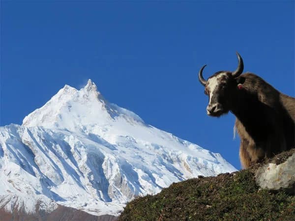
The Manaslu circuit trek is located in the Gorkha district of noorth-central Nepal, regarded as one of the most diverse and rewarding trekking routes. The trail circles Mount Manaslu (8,163 m), the eighth-highest mountain in the world. The region forms part of the Manaslu conservation Area, a protected himalayan landscapes known for its ecological diversity, traditional mountain communities and dramatic elevation changes.
A detailed Manaslu region trekking map reveals how the trail gradually transitions through multiple geographical zones. Trekkers move from subtropical river valleys and terraced farmland to temperate forests of pine and rhododendron, and finally into alpine terrain with glaciers and high mountain passes. This continuous environmental transformation makes the trek feel like a journey through several different worlds in a single expedition.
Compared to Nepal’s more commercial trekking routes, the Manaslu Circuit remains relatively untouched. Limited infrastructure, controlled access, and fewer trekkers help preserve its natural beauty and traditional lifestyle. For those seeking a quieter and more immersive Himalayan experience, the Manaslu region offers a rare balance of wilderness, culture, and high-altitude adventure.
Location and Access for Manaslu Trekking Map
The Manaslu Circuit lies northwest of Kathmandu, close to the Tibetan border. Reaching the starting point requires a long but scenic drive from the capital to Soti Khola or Machha Khola, small settlements at the edge of the Himalayan foothills.
From here, the Manaslu trekking route follows the Budhi Gandaki River, one of the defining natural features of the region. The trail climbs gradually along deep gorges, crossing suspension bridges and passing waterfalls, landslide sections, and steep stone staircases carved into mountain slopes.
As trekkers move northward, the landscape becomes progressively more rugged and alpine. Elevation increases steadily, and vegetation thins as the trail approaches the high mountain environment near Larke La Pass. After crossing the pass, the route descends into the Marsyangdi Valley, marking the transition into the Annapurna region.
Because of its remote location and challenging terrain, reaching and navigating the Manaslu Circuit requires more planning than many other treks in Nepal.
Connection with Annapurna and Tsum Valley
One of the unique geographical features of the Manaslu region is its connection to neighboring Himalayan trekking areas. After crossing Larke La Pass, the trail descends toward Dharapani, where it joins the famous Annapurna Circuit. This natural link allows trekkers to combine two major Himalayan trekking routes into one extended journey, experiencing a wider range of landscapes and cultures.
To the east of the main trail lies Tsum Valley, a secluded high-altitude valley that was opened to trekkers only in recent decades. The valley is deeply influenced by Tibetan Buddhism and is home to ancient monasteries, sacred pilgrimage sites, and traditional villages that have preserved their customs for centuries. Because of its isolation, Tsum Valley provides an even more culturally immersive experience than the main Manaslu Circuit. These route connections make the Manaslu region exceptionally flexible for itinerary planning.
Restricted Area Considerations
The Manaslu region is designated as a restricted trekking area due to its proximity to the Tibetan border and its sensitive cultural environment. The Nepal government regulates tourism here to protect both local communities and fragile mountain ecosystems.
Trekkers must obtain special restricted area permits and travel with a licensed guide. Independent trekking is not allowed. These regulations help manage visitor numbers, reduce environmental pressure, and preserve traditional lifestyles that remain closely tied to Tibetan heritage. Although the permit system adds logistical requirements, it plays an important role in maintaining the region’s authenticity. As a result, the Manaslu Circuit feels less crowded and more culturally intact than many other Himalayan trekking destinations.
Main Trail Route on the Manaslu Circuit Map
The Manaslu Circuit trail map provides a complete visual overview of one of Nepal’s most dramatic trekkingjourneys. The route forms a wide loop around Mount Manaslu, guiding trekkers from low river valleys into the heart of the high Himalayas before descending into the Annapurna region.
By studying the map, trekkers can clearly understand how the trail unfolds in stages. The journey begins in warm, subtropical terrain and gradually transitions into rugged alpine landscapes. Along the way, the map highlights key overnight stops, acclimatization villages, steep elevation gains, and major landmarks such as glaciers, mountain passes, and river crossings.
Most itineraries start at Soti Khola or Machha Khola, follow the Budhi Gandaki valley northward, cross the high Larke La Pass, and descend toward Besisahar, where the trail connects with Annapurna trekking routes. The map makes it easier to visualize this continuous climb and descent, helping trekkers prepare physically and mentally for each stage.
Starting Point: Machha Khola / Soti Khola
The trek begins in the lower foothills of the Himalayas, where the climate is warm and vegetation is dense. From Soti Khola, the trail follows the powerful Budhi Gandaki River, which shapes much of the landscape throughout the early days of trekking.
This section of the route features:
- Narrow trails carved into cliff sides
- Suspension bridges crossing deep gorges
- Waterfalls and landslide zones
- Terraced farms and small rural settlements
The elevation gain here is gradual, allowing trekkers to ease into the rhythm of long walking days. The scenery is dominated by lush greenery, flowing rivers, and steep valley walls, giving a strong sense of entering remote mountain terrain. Machha Khola is typically the first major overnight stop and marks the beginning of the steady northward climb into higher elevations.
Middle Section: Jagat, Deng, Namrung, and Samagaon
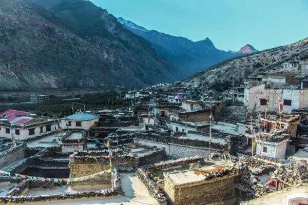
As trekkers move deeper into the mountains, the environment begins to change noticeably. The middle section of the route introduces cooler temperatures, thinner vegetation, and more pronounced elevation gain. This stage includes several important villages like Jagat, Deng, Namrung, Lho and Samagaon.
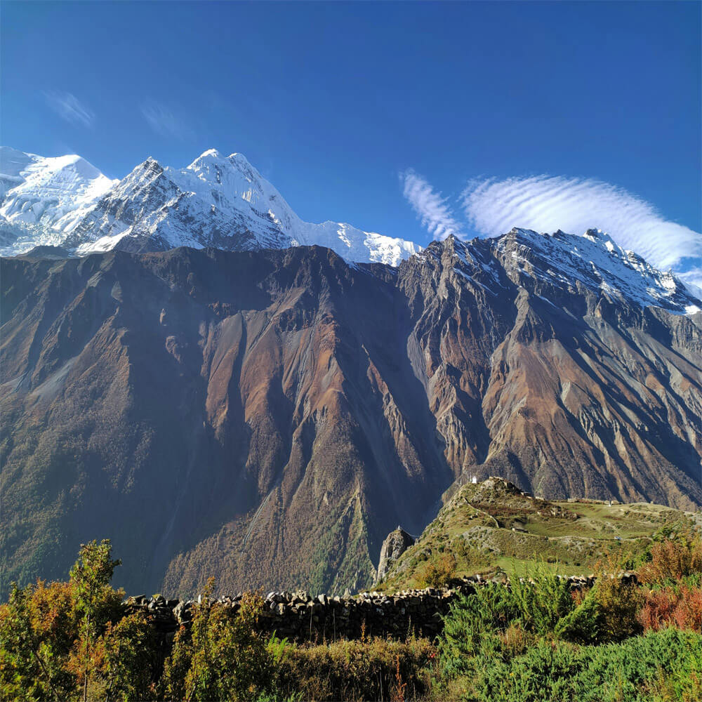
Samagaon is one of the most significant villages on the entire trek. It sits in a wide glacial valley beneath Mount Manaslu and serves as a base for rest days and side excursions. Trekkers often explore nearby monasteries, glacial lakes, or take an optional hike toward Manaslu Base Camp for acclimatization. By this point, the map clearly shows the route approaching high-altitude terrain where careful pacing becomes essential.
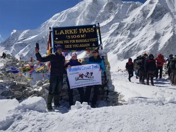
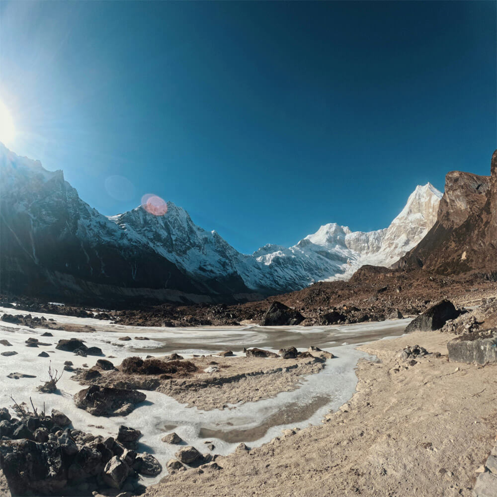
High-Altitude Section: Samdo and Larke La Pass
Beyond Samagaon, the landscapes becomes more barren and windswept. Samdo is the final settlement before the pass as trekkers continue their ascent. From Samdo, the trail continues to Dharmasala (Larke Phedi), the last overnight stop before crossing the pass. This section is shorter but steeper, preparing trekkers for the most challenging day of the journey.
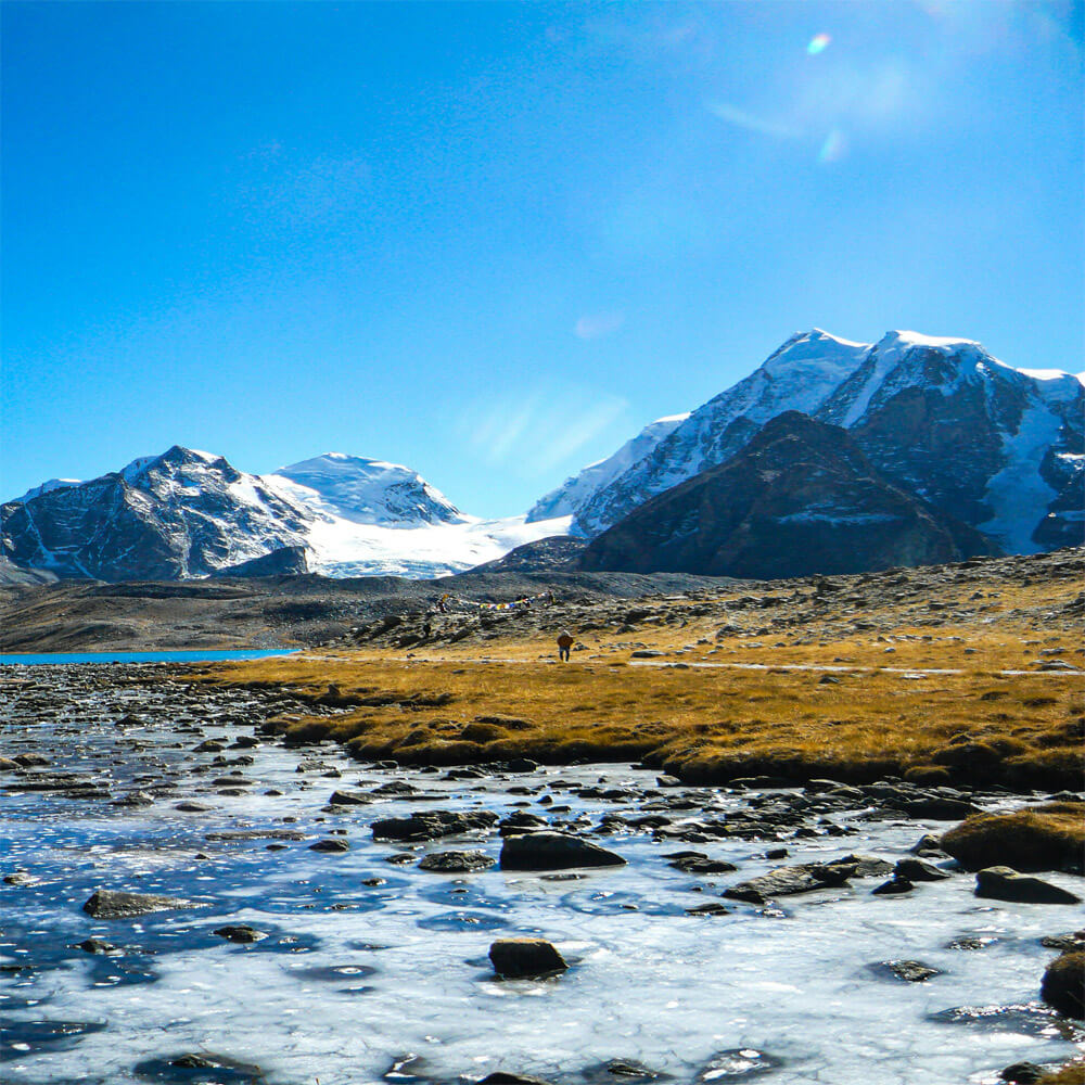
The ascent to Larke La Pass (5,106 m) is the highest and most demanding part of the trek. The route climbs steadily over rocky terrain and snow-covered slopes before reaching the summit of the pass, which provides stunning views of the Annapurnas, Himlung Himal, and Cheo Himal.
Ending Point: Besisahar
After crossing Larkya La, the trail descends toward Bimtang, Dharapani, and then Besisahar after traversing the pass. To help trekkers understand how the route progressively re-enters the lower valleys, the Manaslu circuit trail map provides a clear picture of this decline.
The map clearly illustrates this dramatic descent from high alpine terrain back into lower river valleys, completing the full circuit around Mount Manaslu.Many use this point as a connection to the Annapurna Circuit or to end their journey with a jeep ride back to Kathmandu.
Highlights on the Manaslu Circuit Trek Map
You will notice a number of sites on the Manaslu Circuit Trek map that contribute to making this trip one of Nepal's most memorable. In addition to serving as trailheads, these locations allow trekkers to enjoy the natural beauty, rich cultural heritage, and formidable challenges of the Himalayas.
Manaslu Base Camp
The Manaslu Base Camp trek map shows the side trail that branches off from Samagaon. Trekkers can reach the 4,800 meter high Mount Manaslu Base Camp by taking this detour. It is a well-liked trek for acclimatization prior to ascending to higher elevations.
The trek provides stunning panoramas of the surrounding peaks and glaciers. The map makes it clear that this stretch is an optional addition, although many trekkers consider it to be the high point of the trip.
Larke La Pass: Highest Pass in Manaslu Region trek
The hardest part of the trek is getting over the pass. The Larke Pass trek map highlights the route from Dharmasala up to the pass at 5,106 meters before descending to Bimthang. This is an important spot on the map and the highest point of the Manaslu Circuit. Although the ascent is challenging, the views of Annapurna II, Himlung Himal, Cheo Himal, and Kang Guru make every step worthwhile. Trekkers may better visualize the lengthy descent and high ascent, which call for preparedness and good physical condition, thanks to the map.
Extension of Tsum Valley
Many Manaslu trek maps also mention the route into Tsum Valley as a highlight. Trekkers can discover unexplored communities, traditional Tibetan culture, and hidden monasteries on an optional side trip. Trek maps frequently feature dotted lines on the Tsum Valley trekking trail, even though it is not a part of the main loop, for trekkers who intend to add extra days.
Villages and Cultural Stops
Important villages like Namrung, Samagaon, and Samdo are also marked on maps. These serve as both resting places and cultural hubs where trekkers may mingle with people, visit tea houses, and discover the Tibetan-influenced way of life of area.
By studying the Manaslu base camp trek map and the Larke Pass trek map, trekkers can gain a clear idea of the challenges and highlights that lie ahead. These maps facilitate the planning of cultural events, side trips, and acclimatization, guaranteeing a happy and safe journey.
Trek Distance and Duration on the Manaslu Circuit
Manaslu Circuit Trek is one of the most fulfilling Himalayan treks in Nepal. The circuit, which encircles Mount Manaslu (8,163 m), the eighth-highest mountain in the world, combines hard mountain trails, cultural immersion, and scenic views. It is important for trekkers to know the exact distance and time needed to finish this expedition.
Total Distance of the Trek
Depending on where you start and finish, the Manaslu Circuit Trekking is roughly 177 kilometers (110 miles) long. Besisahar, which also links to the Annapurna Circuit, is where most trekkers end their journey after starting at Soti Khola or Machha Khola. The total distance may increase by additional kilometers due to side journeys, such as to Tsum Valley or Manaslu Base Camp.
Trekking Duration
Trekkers typically take 14-18 days to do the Manaslu Circuit. In communities like Samagaon and Samdo, this includes time for acclimatization days. The amount of time also relies on your level of fitness, walking speed, and whether you want to take any side trips. The danger of altitude sickness may increase with quick ascents, thus a well-paced route is essential.
Manaslu Circuit Trek Distance Chart
Here’s a breakdown of the approximate walking distances between major stops on the Manaslu Circuit:
| Section |
Distance (approx.) |
Trek Duration (hours) |
| Soti Khola -Machha Khola |
14 km |
6-7 hours |
| Machha Khola -Jagat |
22 km |
6-7 hours |
| Jagat - Deng |
19 km |
6-7 hours |
| Deng - Namrung |
19 km |
6-7 hours |
| Namrung - Samagaon |
17 km |
6-7 hours |
| Samagaon - Samdo |
12 km |
4-5 hours |
| Samdo - Dharamsala (Larke Phedi) |
11 km |
4-5 hours |
| Dharamsala - Larke La - Bimthang |
16 km |
8-9 hours |
| Bimthang -Tilije |
19 km |
6-7 hours |
| Tilije - Dharapani/Besisahar |
15 km |
6-6 hours |
Understanding the Manaslu Circuit trek distancechart helps trekkers plan their itinerary realistically. Every step of the journey offers breathtaking Himalayan landscape and cultural experiences, but it also calls for patience, endurance, and progressive acclimatization.
Lowest Point on the Trek
The lowest point of the trek is located between 710 and 930 meters above sea level, Soti Khola or Machha Khola is typically where the trek starts. The terrain is lovely at this point, with rivers, trees, and pleasant temperatures. Compared to the higher portions of the walk, the beginning feels relatively easy because of this lower elevation.
Why the Elevation Map Matters?
In addition to showing heights, the elevation chart indicates areas where altitude sickness risks may be higher. Trekkers can determine where they might require an additional acclimatization day by looking at the elevation map for the Manaslu hiking trip. For instance, before crossing the pass, many itineraries advise staying an extra night in Samagaon or Samdo.
The elevation map also helps trekkers understand how quickly the altitude increases along the route. Rapid elevation gain is one of the main causes of altitude-related illnesses, and the Manaslu Circuit includes several steep climbs within a short distance. By studying the altitude profile in advance, trekkers can plan gradual ascents, monitor their physical condition, and avoid pushing too hard on critical days.
Another important benefit is mental preparation. Knowing when the trail reaches its highest points especially near Larke La Pass helps trekkers anticipate more physically demanding sections. This allows for better pacing, energy management, and realistic daily walking plans.
Why a Map is Useful for Trekkers?
A map is an essential tool for trekkers because it provides a clear visual understanding of the route, distance, elevation changes and key landmarks along the trail. It improves safety, navigation and confidence which allows trekkers to explorew the region more efficiently and with greater peace of mind.
Understanding the Trekking Route with a Manaslu Trekking Itinerary as Per the Map
When planning the Manaslu trekking itinerary map, trekkers quickly realize how valuable it is to visualize each day’s journey. From the lower settlements with green hillsides to the high alpine scenery close to Larke La Pass, the map illustrates the progression. Trekkers can make better decisions about how many days to stay in each location and where to take acclimatization breaks when they see the route clearly marked out.
A clearly indicated itinerary map also identifies other possible side journeys, such a detour into the Tsum Valley or the drive to Manaslu Base Camp. Trekkers can now confidently alter their itinerary while remaining secure thanks to this.
Locating Stops with a Manaslu Trekking Villages Map
Another benefit of using a Manaslu trekking villages map is that it pinpoints the villages and settlements along the route. The Manaslu Circuit provides a chain of settlements where trekkers can dine, relax, and spend the night, in contrast to some isolated treks with lengthy distances between teahouses.
Clear markers on the map indicate the locations of villages like Jagat, Deng, Namrung, Samagaon, and Samdo, which aid trekkers in organizing their stops. To pace the journey, prevent overexertion, and guarantee that each day concludes with cozy lodging, it is very beneficial to know the precise distance between these villages.
Safety and Navigation Advantages
A map serves as a safety tool in addition to being a guide. The Manaslu region has rough terrain, and inclement weather can occasionally make the track difficult to follow. Trekkers may comfortably navigate, recognize landmarks, and compare their progress to their planned timetable with the help of a detailed itinerary or village map. In the event that a road or trail is closed, maps also provide checkpoints, the limits of restricted areas, and alternate routes.
Combining Paper and Digital Maps
It is advised that trekkers bring both digital equipment and a physical walking map. Even in isolated locations, paper maps are dependable and never run out of battery. However, real-time location tracking is available with GPS-based applications. Trekkers will always know where they are and how far they have to travel if they use both, which makes the trip safer and more pleasurable.
Manaslu Conservation Area Map
The Manaslu Conservation Area (MCA) map is an essential guide for trekkers exploring the Manaslu Circuit and its surrounding regions. The protection area, which covers more than 1,663 square kilometers and encompasses the districts of Gorkha and Lamjung, features a range of landscapes, including glaciated peaks, alpine meadows, and subtropical woods. Trekkers can better envision the main track, important settlements, rivers, high passes, such as the well-known Larke La Pass (5,106 m), and detours to Manaslu Base Camp with the aid of a map.
In addition, the map shows regions of rich biodiversity including snow leopards, red pandas, and Himalayan tahr, as well as significant cultural and environmental features like traditional Gurung and Tibetan-influenced communities, monasteries, and sacred sites in the Tsum Valley. Marked tea houses and lodges direct overnight stops, and elevation profiles on the map help in acclimatization planning.
Whether digital or paper-based, using a map when trekking greatly improves route planning and safety. Working with a reputable organization like Nepal Trekking Routes guarantees access to precise maps, local advice, and support during the trip, making for a well-planned and educational experience. In addition to serving as a navigational aid, the Manaslu Conservation Area map allows visitors to enjoy the natural and cultural diversity of the area.
Manaslu-Annapurna Connection Map
The Manaslu-Annapurna connection map shows the trekking link between the Manaslu Circuit and the Annapurna region, offering adventurous trekkers the opportunity to explore both regions in a single journey. Starting at Soti Khola, this route usually travels via important Manaslu villages like as Jagat, Deng, Namrung, Samagaon, and Samdo. It also traverses the Larke La Pass (5,106 m) and then gradually descends until the Marsyangdi Valley near Besisahar, which is part of Annapurna.
Trekkers can use the map to plan their acclimatization, rest stops, and overnight stays by highlighting important route junctions, rivers, communities, and high passes. Depending on time and fitness level, it can also indicate alternate routes, including detours to Tsum Valley or Manaslu Base Camp. Using the connection map, trekkers can better visualize elevation changes, daily distances, and trail logistics.
Digital vs. Paper Map Options
Both digital and paper maps have their own advantages on the Manaslu Circuit Trekking in Nepal. Many experienced trekkers prefer carrying both, using digital maps for navigation and paper maps as a reliable backup.
Digital Maps for Trekking in Nepal
Nowadays, a lot of trekkers prefer to use digital maps when they are trekking in Nepal. Real-time tracking via GPS devices and mobile apps helps tourists stay on the correct path. The ability to download and use offline makes apps like Maps.me, AllTrails, and Himalayan trekking maps dependable even in isolated alpine locations without internet access.
Convenience is the primary advantage of digital maps; they are portable and instantly display your current location. In order to facilitate daily planning, digital maps of the Manaslu Circuit Trek also show elevation variations, alternate routes, and tea shops in the area.
Paper Maps for Trekking in Nepal
Despite the widespread use of digital technologies, printed maps are still a reliable trekking companion in Nepal. They are generally accessible in trekking stores in Kathmandu and Pokhara, and they frequently include comprehensive maps of the communities, routes, elevations, and side trips, such as those to Tsum Valley.
Paper maps are reliable in high-altitude situations where electronics may malfunction since they are not reliant on batteries or cell networks. In the evening, many trekkers like to study paper maps in tea rooms, charting the route and talking with guides and other passengers about the next day's travels.
Combining both of the Options
The best approach for trekking in Nepal is to carry both digital and paper maps. While paper maps are a dependable backup and provide a comprehensive overview of the entire journey, digital maps are practical for navigating while on the go. Possessing both guarantees flexibility, safety, and a more fulfilling trekking experience.
Tips for Using the Manaslu Trek Map
When trekking in Nepal, especially on the Manaslu Circuit, a map is more than just a piece of paper. It is a reliable manual that explains where you are, where you are heading, and how to prepare. Here are some useful pointers to help you get the most out of your journey map.
Learn to Read the Map Before You Start
Before you start your adventure, take some time to examine the map. Recognize the symbols, altitude markers, and trail path. Identify the locations of rivers, tea houses, and settlements. Once you are on the route, it is easy to navigate thanks to this preparation.
Check Alternative Routes and Side Trails
Tsum Valley and Manaslu Base Camp are two frequent side treks that link to the Manaslu Circuit. A excellent map draws attention to these extensions. Knowing these routes allows you to be flexible when Nepal trekking, allowing you to cut or lengthen your trip.
Track Elevation and Acclimatization Points
On this trek, altitude is crucial. Locate safe acclimatization locations, such as Samagaon and Samdo, using the map. You can prevent altitude sickness and make informed journey plans by being aware of the locations of moderate climbs.
Combine Map with Local Guidance
Combining a map with local guidance ensures that trekkers can make informed decisions in real time, avoid potential hazards, and adjust their itinerary if unexpected conditions arise. This partnership not only enhances safety but also enriches the trekking experience, allowing you to learn about local culture, history, and natural landmarks directly from people who live in the region.
Carry Both Digital and Paper Maps
While digital apps and GPS devices provide real-time location tracking, route guidance, and offline access to trail details, they rely on battery life and can sometimes fail in extreme weather or high-altitude conditions.
On the other hand, paper maps are completely reliable, offering a broad view of the entire trek, showing key landmarks, villages, rivers, and elevation changes without depending on technology.
Conclusion: Manaslu Circuit Trek Map
A well-detailed Manaslu Circuit Trek map is an essential tool for any trekker planning to explore this remote and spectacular region. The map makes it easier to see the route from Soti Khola to Larke La Pass, which leads to Besisahar via Jagat, Deng, Namrung, Samagaon, and Samdo. Along with important sites like Tsum Valley and Manaslu Base Camp, it also identifies acclimatization points, tea houses, and elevation variations. Using a map helps with navigation, safety, and effective daily distance planning.
Our company, Nepal Trekking Routes is a great choice for a more seamless trekking experience. We offer professional direction, thorough route maps, and logistical support all of which are crucial in this restricted area. The Manaslu Circuit Trek is a safe, well-planned, and remarkable Himalayan experience that trekkers may comfortably enjoy by bringing both a digital and paper map and local supervision.