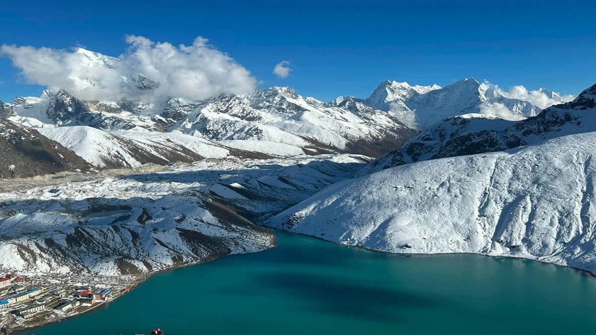
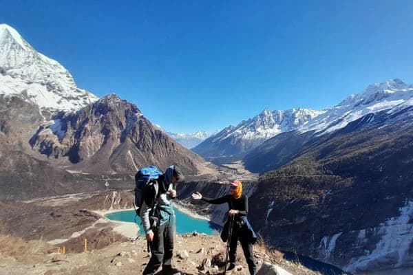
Gokyo Lakes are not one lake. They are a group of high altitude glacial lakes in the Gokyo Valley of Nepal’s Everest region. The lake most people call Gokyo Lake is Gokyo Cho, also known as Dudh Pokhari. It is the lake next to Gokyo village, at an elevation of about 4,734 metres.
The wider Gokyo lake system reaches from about 4,690 to 5,000 metres and is closely connected with the Ngozumpa Glacier and the upper Dudh Koshi watershed. The area was declared a Ramsar wetland in 2007. Gokyo Lakes also have religious importance for Hindu and Buddhist communities.
What are the Gokyo Lakes actually called? Where are they located, how were they formed, and which one has the highest Gokyo Lake altitude? The answers involve glaciers, ancient ice and the unusual geology of this part of the Himalayas.
Where Are the Gokyo Lakes Located?
The Gokyo Lakes are in Gokyo Valley, in Solukhumbu District of northeastern Nepal. The valley is part of the Khumbu region and lies within Sagarmatha National Park. Gokyo village is next to Gokyo Cho, commonly known as Gokyo Lake or Dudh Pokhari.
The valley is reached from the main Khumbu region trekking route after you go through Namche Bazaar, Dole, Machhermo, and finally reaches Gokyo. The lakes are surrounded by high mountain peaks, and Cho Oyu to the north and Ngozumpa Glacier close to the lake area.
The Gokyo Lakes range from about 4,700 metres to nearly 5,000 metres above sea level. Their high altitude is one of the defining features of Gokyo Valley and also explains why the landscape changes from the lower parts of the Everest region.
Gokyo Lakes Altitude
The six lakes of the Gokyo Lake Cluster lie across an elevation range of roughly 4,680 to 5,000 metres, although published measurements differ depending on the lake and the area being measured. The official Ramsar record gives the following elevations for the main lakes:
| Lake |
Elevation |
| Longpanga Tsho |
4,668 to 4,710 m |
| Taujung Tsho |
4,710 to 4,740 m |
| Gokyo Cho (Dudh Pokhari) |
4,790 m |
| Thonak Tsho |
4,840 to 4,870 m |
| Ngozumpa Tsho |
4,956 to 4,980 m |
| Gyazumpa Tsho |
5,000 to 5,050 m |
The figures are also useful when discussing the Gokyo Lakes elevation, Gokyo Lake height, or the altitude of a particular lake rather than the lake system as a whole.
The Gokyo Lakes trek reaches these elevations slowly through the upper Khumbu. By the time trekkers arrive in Gokyo Valley, they are already at almost 4,700 metres, and that is why acclimatization is an important part of the journey.
Major Lakes of Gokyo
When people talk about the Gokyo Lakes in Nepal, they are usually thinking of the blue lake beside Gokyo village. That is Gokyo Cho, also called Dudh Pokhari, but it is only one part of a much larger lake cluster.
The Gokyo Lake Cluster consists of six lakes, usually identified from south to north as Lake 1 through Lake 6. Gokyo Cho, or Dudh Pokhari, is Lake 3 and the lake beside Gokyo village. Their names appear with slightly different spellings in maps, scientific papers and trekking literature. That is why you may come across Tanjung instead of Taujung, Ngojumba instead of Ngozumba, or Longbanga instead of Longpanga.
The lakes are not identical. They occupy separate basins, have different depths and sizes, and are influenced by water coming from glacial melt, seepage, streams and precipitation. The whole Gokyo lake system lies beside the enormous Ngozumpa Glacier and forms part of the upper Dudh Koshi watershed.
Longpanga Tsho
Longpanga Tsho is the first named lake in the sequence. You may also find it written as Longbanga Cho.
It is a small lake and is remarkably shallow compared with the larger lakes farther up the valley. Scientific measurements have recorded a maximum depth of only about one metre. That difference becomes striking when you compare it with Thonak Cho, which has a measured depth of more than sixty metres.
Longpanga is not the lake most visitors come to Gokyo to see, but it helps explain the character of the Gokyo wetland. The six lakes are not six similar bodies of water placed along a trekking trail. Their basins developed differently and have different connections with the surrounding drainage.
Around the first lake, the landscape is already distinctly alpine, with sparse vegetation, exposed rock and deposits left by glaciers. As the trail continues towards Gokyo village, the influence of the old and present glacial environment becomes increasingly obvious.
Taujung Tsho
Taujung Tsho is the second lake. Tanjung Cho and Taujung Tsho are two other spellings you may encounter when researching the Gokyo Valley lakes.
This lake reaches a measured maximum depth of 33.3 metres, making it far deeper than Longpanga. It is also connected to the neighbouring lakes through the drainage network of the valley.
That connection is an important part of the story. Water in the Gokyo wetland does not exist as six completely isolated pools. The lower lakes are linked by streams and drainage, while seepage and meltwater from the surrounding glacial environment contribute to the water supply.
Taujung is therefore useful when explaining the hydrology of Gokyo Lakes. It shows how the lakes function as part of one high Himalayan wetland rather than as unrelated mountain ponds.
Gokyo Tsho
Gokyo Tsho is the lake that most travellers mean when they say Gokyo Lake. It is also known as Dudh Pokhari, and Gokyo village is built beside its eastern shore.
This is the lake that dominates photographs of the Gokyo Valley Trek. Walk through the village and the water is right beside you. Climb towards Gokyo Ri and the lake opens out below, with the surrounding mountains and glacial landscape becoming easier to understand from above.
Gokyo Tsho reaches a measured maximum depth of about 43 metres. It is also considerably larger than Longpanga and Taujung.
The name Dudh Pokhari means Milk Lake, and the lake has religious importance for both Hindus and Buddhists. During religious gatherings, pilgrims come to this high Himalayan lake for worship and ritual bathing.
There is also an important distinction for anyone searching online. Gokyo Lake, Gokyo Cho and Dudh Pokhari refer to the same main lake, while Gokyo Lakes refers to the wider group.
Thonak Tsho
Thonak Tsho is the fourth lake and one of the most interesting from a geological point of view.
It has the largest recorded surface area among the main lakes and is also the deepest Gokyo Lake with a detailed published bathymetric measurement. Researchers measured a maximum depth of 62.4 metres.
That depth is significant because the lake can look deceptively calm from the shore. Beneath the surface is a much deeper basin shaped by the processes that created the surrounding glacial landscape of the Everest region.
Thonak is farther from Gokyo village, so the experience changes as you approach it. The buildings and busy walking trails around the villages are left behind, and the surrounding moraine, rock and ice shaped land become much more noticeable.
The lake sits within the wider influence of the Ngozumpa Glacier. Research into the Gokyo lakes describes the larger basins as moraine dammed glacial lakes, with their depressions and surrounding barriers closely related to past glacial activity.
This makes Thonak particularly valuable for anyone interested in the geology of Gokyo Valley, rather than only its trekking scenery.
Ngozumba Tsho
Ngozumba Tsho is the fifth lake and lies farther into the upper valley. It is also written as Ngojumba Cho or Ngozumpa Tsho in different sources.
This is where the Ngozumpa Glacier becomes an even more obvious part of the landscape. The glacier lies immediately alongside the lake system, and its meltwater and seepage contribute to the hydrology of the Gokyo wetland.
Ngozumba is also the lake to mention when discussing the Gokyo fifth lake viewpoint and the wider mountain panorama beyond Gokyo village.
On a clear day, Mount Everest can be seen from the area around the fifth lake, along with other major peaks of the Khumbu. Everest does not appear clearly every day because cloud can move across the high mountains very quickly, but good visibility can produce an exceptional view from this part of the valley.
The fifth lake is therefore quite different from Gokyo Cho. Gokyo Cho is closely associated with the village, religious activity and the main trekking route. Ngozumba takes you deeper into the glacial environment and gives a stronger sense of how close the Gokyo Valley is to the high ice fields around Cho Oyu.
There is less reliable published information about its exact depth than there is for the second, third and fourth lakes. It is better not to attach an unsupported depth figure to Ngozumba Tsho just to make the article appear more detailed.
Gyazumpa Tsho
Gyazumpa Tsho is the sixth lake generally included in descriptions of the Gokyo Lakes system. It is farther into the upper valley and is much less familiar to ordinary trekkers.
Most visitors concentrate on Gokyo Tsho, Gokyo Ri and the nearby lakes. Gyazumpa is part of the less visited end of the lake cluster, where the surroundings become increasingly remote and dominated by glacial deposits and exposed mountain rock.
This lake is also a good example of why information about Gokyo should be checked carefully. The spelling of the lake name varies between sources, and detailed scientific measurements are not available for every characteristic of the upper lakes.
Taken together, these six lakes show what makes Gokyo Valley in the Everest region different from a single scenic lake destination. The first lakes are connected with the lower part of the wetland and the Dudh Koshi drainage, Gokyo Cho lies beside the village and forms the centre of the trekking experience, while Thonak, Ngozumba and Gyazumpa lead farther into the glacial landscape beside the Ngozumpa Glacier.
The result is a lake system shaped by ice, water and the changing geography of the upper Khumbu, rather than a collection of beautiful lakes along a trekking route.
How Were the Gokyo Lakes Formed?
The formation of Gokyo Lakes is closely linked to the glaciers that once covered much of this part of the Himalayas. As the ice moved through the valleys, it slowly wore away the rock beneath and along its sides. This created deep hollows and wider valley floors where water could later collect.
When the glaciers retreated, they left behind large amounts of rock, gravel and sediment. These deposits formed ridges called moraines. In the Gokyo Valley, some of these moraines act as natural dams, which is why the lakes are often described as moraine dammed lakes in Nepal.
After the glaciers retreated, water collected in the basins they had carved and was held behind moraine deposits. The lakes now receive water from glacier melt, precipitation and seepage, but their connections are not all the same. Lakes 1, 2 and 3 have surface streams leading towards the Dudh Koshi, while Lakes 4 and 5 have no surface outflow.
The Gokyo Lakes glacial formation is also connected with the history of the Ngozumpa Glacier. The major lake basins occupy valleys carved by smaller glaciers that once joined the larger glacial system. The lateral moraine along the Ngozumpa Glacier later helped contain the water within the valley. Scientific research has identified this relationship between the lake basins, former tributary glaciers and the Ngozumpa Glacier moraine.
There is another type of lake in the same area that should not be confused with the Gokyo Lakes. Water can also collect directly on the surface of a glacier, forming what is called a supraglacial lake. These small water bodies occur on the debris covered surface of Ngozumpa Glacier and can appear, expand or drain as the glacier changes.
So, the Gokyo Lakes geological formation involved several processes over a long period. Moving ice carved the valleys, retreating glaciers left behind moraines, and water later occupied the depressions created by this glacial activity. The lakes people see today are part of that much older Gokyo Lakes glacial history.
Why Are the Gokyo Lakes Blue?
The Gokyo Lakes turquoise color comes from very fine rock particles produced by glacial erosion. These particles, known as glacial flour, can remain suspended in the water and affect how sunlight is scattered and absorbed. This gives the water its blue or turquoise appearance.
Water depth, suspended sediment and sunlight also affect the colour seen from the shore. The Gokyo Lakes blue water can therefore look different under changing weather and light conditions.
The colour is a natural feature of a high Himalayan glacial lake system, not just a reflection of the sky.
Why Are Gokyo Lakes Sacred?
The religious significance of Gokyo Lakes comes from their place in Hindu belief and local Sherpa culture. The lakes are considered sacred, and religious visits continue alongside the area’s use as a trekking destination.
Hindus associate Gokyo as the residence of Nag Devata, the snake god. Devotees worship the deity at the lakes, and people from Namche visit Gokyo during Janai Purnima, the full moon festival in Shrawan. The visit includes religious observance at the sacred lake.
Gokyo also has strong Sherpa cultural significance. The lake area forms part of the traditional cultural landscape of the Khumbu region, where natural places can hold religious meaning alongside their everyday use. The Ramsar record identifies Gokyo as a place of religious and Sherpa cultural importance.
Wildlife and Plants Around Gokyo Lakes
More than 80 flowering plant species have been recorded around the Gokyo Lakes, including Him Chimal (Rhododendron nivale), Sunpate (Rhododendron anthopogon), Rhododendron lepidotum, Potentilla fruticosa, Primula sikkimensis, Gentiana algida, Meconopsis horridula, Kobresia, Juncus and Festuca species. The area also contains species such as Swertia multicaulis and Saussurea gossipiphora.
The Gokyo Lakes plants are mostly small flowering species, grasses, sedges and low shrubs rather than tall vegetation. The Ramsar site also identifies Kobresia fissiglumis as an endemic flowering plant and lists kutki (Neopicrorhiza scrophulariifolia) among the notable plant species found in the wider Gokyo wetland.
Among the Gokyo Lakes wildlife, Himalayan pikas are specifically recorded in the lake catchment, while Himalayan tahr occur in the surrounding rangelands. Red foxes and stone martens have also been recorded at the site. Himalayan tahr and pika are relevant to the local food chain because they provide prey for carnivores, including snow leopards found in the lower part of the catchment.
Bird records from the Gokyo wetland include Eurasian woodcock and great crested grebe, while the wider Sagarmatha National Park supports many other high altitude bird species.
How to Reach Gokyo Lakes
The usual route to Gokyo Lakes starts with a flight from Kathmandu to Lukla. From Lukla, trekkers move towards Namche Bazaar, Dole, Machhermo, and finally reach Gokyo.
Gokyo is also connected with other trekking routes in the Khumbu region of Nepal. The Gokyo Renjo La Pass Trek links Gokyo with Thame, while the Cho La Pass Trek connects Gokyo with the Everest Base Camp area. The Everest Three Passes Trek also includes Gokyo as one of its major stops.
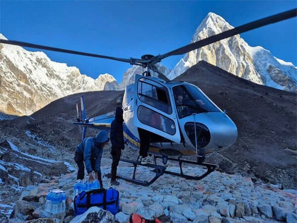
Helicopter flights from Kathmandu can also reach Gokyo, which makes it possible to visit the lakes without completing the full journey on foot. Trekking from Lukla, however, gives a clear view of the changing landscape from the lower Khumbu to the high alpine lakes.
Lesser Known Facts About Gokyo Lakes
- No fish have been recorded in the sampled Gokyo Lakes. The lakes still contain algae, zooplankton and other small aquatic organisms.
- Gokyo Lake water is calcium and bicarbonate rich. The surrounding rocks influence its water chemistry, not just melting ice.
- The lakes freeze for roughly three to four months each year. Thawing of the lake normally begins towards the end of winter.
- Gokyo Lakes belong to the Dudh Koshi headwaters. Water from this high lake system eventually joins the larger Dudh Koshi river network.
- More than 1,000 smaller glacial lakes have been identified in the Ngozumpa Glacier basin. Most are supraglacial lakes formed on or within the glacier itself, so they are separate from the six named Gokyo Lakes.
- The Gokyo Ramsar wetland covers approximately 7,770 hectares. The protected area is therefore much larger than the water surface of the six main lakes.
- Lake sediments preserve microscopic remains. Diatoms and chironomids in the sediment can be used to examine past environmental conditions in the area.
Final Thoughts
Gokyo Lakes, Nepal are more than a scenic group of lakes in the Everest region. Their connection with the Ngozumpa Glacier, glacial history, Dudh Koshi watershed and local religious traditions makes Gokyo Valley an important part of the Himalayas.
The Gokyo Lakes trekking brings these features together, with Gokyo Ri and the surrounding peaks adding another perspective of the valley. The lakes are beautiful, but their geology, history and cultural importance make them far more interesting than their appearance alone.